Back سیکونک، ماساچوست AZB Seekonk Catalan Сиконк (Массачусетс) CE Seekonk CEB Seekonk, Massachusetts Welsh Seekonk (Massachusetts) Spanish Seekonk (Massachusetts) Basque سیکانک، ماساچوست Persian Seekonk French Seekonk, Massachusetts HT
Seekonk, Massachusetts | |
|---|---|
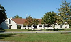
 Seekonk Town Hall | |
 Location in Bristol County in Massachusetts | |
| Coordinates: 41°48′30″N 71°20′15″W / 41.80833°N 71.33750°W | |
| Country | United States |
| State | Massachusetts |
| County | Bristol |
| Settled | 1636 |
| Incorporated | 1812 |
| Government | |
| • Type | Open town meeting |
| • Administrator | Shawn E. Cadime |
| • Selectmen |
|
| Area | |
• Total | 18.32 sq mi (47.7 km2) |
| • Land | 18.22 sq mi (47.4 km2) |
| • Water | 0.10 sq mi (0.3 km2) |
| Elevation | 50 ft (15 m) |
| Population (2020) | |
• Total | 15,531 |
| • Density | 850/sq mi (330/km2) |
| Time zone | UTC-5 (Eastern) |
| • Summer (DST) | UTC-4 (Eastern) |
| ZIP code | 02771 |
| Area code | 508 / 774 |
| FIPS code | 25-60645 |
| GNIS feature ID | 0618286 |
| Website | www |
Seekonk is a town in Bristol County, Massachusetts, United States, on the Massachusetts border with Rhode Island. It was incorporated in 1812 from the western half of Rehoboth. The population was 15,531 at the 2020 census.[1] In 1862, under a U.S. Supreme Court decision resolving a longstanding border dispute between Massachusetts and Rhode Island, a portion of Tiverton, Rhode Island was awarded to Massachusetts to become part of Fall River, while two-thirds of Seekonk (now eastern Pawtucket and East Providence) was awarded to Rhode Island.[2][3]
- ^ "Census - Geography Profile: Seekonk town, Bristol County, Massachusetts". United States Census Bureau. Retrieved November 11, 2021.
- ^ History of Bristol County
- ^ Cady, John Hutchins (1936). Rhode Island Boundaries 1636-1936. Rhode Island Tercentary Commission., pp 1-31.

