Back Seodaemun-gu CEB Seodaemun-gu German Seodaemun-gu Esperanto Seodaemun-gu Spanish Seodaemuni ringkond Estonian ناحیه سودهمون Persian Seodaemun-gu French Seodaemun (Steedkreis) FRR Szodemun-ku Hungarian Distrik Seodaemun ID
This article needs additional citations for verification. (May 2010) |
Seodaemun
서대문구 | |
|---|---|
| 서대문구 · 西大門區 | |
 Location of Seodaemun District in Seoul | |
| Coordinates: 37°34′45″N 126°56′12″E / 37.57917°N 126.93667°E | |
| Country | South Korea |
| Region | Sudogwon |
| Special City | Seoul |
| Administrative dong | 14 |
| Government | |
| • Body | Seodaemun District Council |
| • Mayor | Lee Sung-heon (People Power) |
| • MNAs | List of MNAs |
| Area | |
• Total | 17.61 km2 (6.80 sq mi) |
| Population (2010[1]) | |
• Total | 313,814 |
| • Density | 18,000/km2 (46,000/sq mi) |
| Demonym | 서대문구민 (Seodaemun gumin) |
| Time zone | UTC+9 (Korea Standard Time) |
| Postal code | 03600 – 03899 |
| Area code | +82-2,300,700,3150~ |
| Flower | Rose |
| Tree | Pine tree |
| Bird | Korean magpie |
| Website | Seodaemun District official website |
 | |

Seodaemun District (Korean: 서대문구; RR: Seodaemun-gu) is one of the 25 districts of Seoul, South Korea. It has a population of 313,814 (2010) and has a geographic area of 17.61 km2 (6.8 sq mi), and is divided into 14 dong (administrative neighborhoods). Seodaemun is located in northwestern Seoul, bordering the city districts of Eunpyeong to the northwest, Mapo to the southwest, Jung to the southeast, and Jongno to the east.
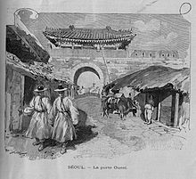
Seodaemun is part of the Seongjeosimni (Outer old Seoul) area and is named after Donuimun, one of the Eight Gates of Seoul which was formerly located within the district. Seodaemun is home to Seodaemun Independence Park, which contains several historic monuments and buildings such as the Seodaemun Prison museum and the Independence Gate.


