Back سيريو Arabic Serio BAR Fiume Serio CEB Серио (юханшыв) CV Serio German Río Serio Spanish Serio Estonian رودخانه سریو Persian Serio (rivière) French Serio Italian
This article needs additional citations for verification. (May 2010) |
| Serio | |
|---|---|
 | |
 | |
| Location | |
| Country | Italy |
| Physical characteristics | |
| Source | |
| • location | Monte Torena, Italy |
| • elevation | 2,583 m (8,474 ft) |
| Mouth | Adda |
• location | Bocca di Serio, south of Crema |
• coordinates | 45°15′29″N 9°41′37″E / 45.2581°N 9.6936°E |
| Length | 124 km (77 mi) |
| Basin features | |
| Progression | Adda→ Po→ Adriatic Sea |
| Tributaries | |
| • left | Bondione, Ogna, Romna |
| • right | Acqualina, Morla |
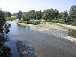
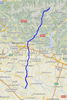
The Serio (Lombard: Sère[1][2]) is an Italian river that flows entirely within Lombardy, crossing the provinces of Bergamo and Cremona. It is 124 kilometres (77 mi) long and flows into the Adda at Bocca di Serio south of Crema. Similar to all Lombardian rivers, it forms part of the Po drainage area.
Its valley is known as the Val Seriana.
- ^ Randall Rogers (1997), Latin Siege Warfare in the Twelfth Century, Oxford University Press, ISBN 978-0-19-820689-7, retrieved 11 Dec 2011
- ^ Roy Palmer Domenico (2002), The Regions of Italy: a Reference Guide to History and Culture, Greenwood Publishing Group, p. 195, ISBN 978-0-313-30733-1, retrieved 11 Dec 2011