Back Setagaya, Tokyo ACE سيتاغايا (طوكيو) Arabic سيتاجايا ARZ Setaqaya Azerbaijani সেটাগায়া Bengali/Bangla Setagaya Catalan Сэтагая CE Setagaya-ku CEB Setagaya Danish Setagaya German
Setagaya
世田谷区 | |
|---|---|
| City of Setagaya | |
 | |
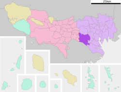
 Location of Setagaya in Tokyo | |
| Coordinates: 35°38′47.66″N 139°39′11.69″E / 35.6465722°N 139.6532472°E | |
| Country | Japan |
| Region | Kantō |
| Prefecture | Tokyo |
| First official recorded | middle 15th century |
| As Tokyo City | October 1, 1932 |
| As Special ward of Tokyo | July 1, 1943 |
| Government | |
| • Mayor | Nobuto Hosaka (since May 2011) |
| Area | |
• Total | 58.06 km2 (22.42 sq mi) |
| Population (July 1, 2023) | |
• Total | 940,071 |
| • Density | 16,000/km2 (42,000/sq mi) |
| Time zone | UTC+09:00 (JST) |
| Postal code(s) | 154 to 158 (First three digits) |
| Area code | 03 |
| Website | www |
| Symbols | |
| Bird | Azure-winged magpie |
| Flower | Habenaria radiata |
| Tree | Zelkova serrata |
Setagaya (世田谷区, Setagaya-ku, officially called Setagaya City or the City of Setagaya) is a special ward in the Tokyo Metropolis in Japan. It is also the name of a neighborhood and administrative district within the ward. Its official bird is the azure-winged magpie, its flower is the fringed orchid, and its tree is the Zelkova serrata.
Setagaya has the largest population and second-largest area (after Ōta) of Tokyo's special wards. As of July 1, 2023, the ward has an estimated population of 940,071, and a population density of 16,194 persons per km² with the total area of 58.06 km².


