Back مزارع شبعا Arabic مزارع شبعا ARZ Фэрмы Шэбаа BE-X-OLD Ферми на Шабаа Bulgarian Granges de Xebaa Catalan Farmy Šibáa Czech Schebaa-Farmen German Farmobienoj de Ŝebao Esperanto Granjas de Shebaa Spanish Shebaako etxaldeak Basque

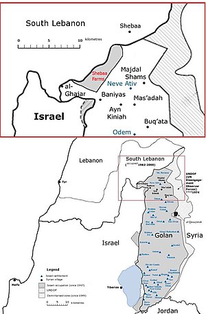
The Shebaa Farms, also spelled Sheba'a Farms (Arabic: مزارع شبعا, Mazāri' Šib‘ā; Hebrew: חוות שבעא Havot Sheba‘a), also known as Mount Dov (Hebrew: הר דב, romanized: Har Dov), is a strip of land on the Lebanese–Syrian border that is currently occupied by Israel. Lebanon claims the Shebaa Farms as its own territory, and Syria agrees with this position. Israel claims it is part of the Golan Heights, Syrian territory that it has occupied since 1967 and effectively annexed in 1981. This dispute plays a significant role in contemporary Israel–Lebanon relations.
The territory is named for the farms within it which were historically tended by the inhabitants of the Lebanese town of Shebaa. It is about 11 kilometres (7 mi) long and 2.5 kilometres (2 mi) wide. The French Mandate for Syria and the Lebanon administration did not demarcate the border between Lebanon and Syria, nor was this done later by Lebanese and Syrian governments. Documents from the 1920s and 1930s indicate that inhabitants paid taxes to the Lebanese government. From the early 1950s to Israel's occupation of the Golan Heights in the Six-Day War, Syria was the de facto ruling power.[1] In 1978 Israel invaded and occupied Southern Lebanon. In 1981, the Golan Heights, including the Shebaa Farms, were annexed by Israel, a move not recognized by the international community.[2] Israel considers it part of the Golan Heights and continues to hold it, along with the Golan, under military occupation.[3]
The territory has been a flashpoint for violence since Israel withdrew from Lebanon in May 2000.[4] Hezbollah claimed that the withdrawal was not complete because Shebaa was on Lebanese – not Syrian – territory.[5] Following the Israeli withdrawal, the UN certified the completion of Israel's pullout.[6] Later the United Nations Secretary General issued a statement proposing the area for the operations of the United Nations Interim Force in Lebanon; in the statement the controversy was described, with 81 different maps being studied; the UN concluded that there is no evidence of the abandoned farmlands being Lebanese, but proposed to maintain the existing boundaries of the United Nations Disengagement Observer Force in Syria (which had included the Shebaa Farms since 1967) "without prejudice" to any future agreement between Syria and Lebanon.[7][8]
Low-level conflict continued in the area from 2000 to 2006 and in early 2015. In August 2008, the president of Lebanon, Michel Suleiman, stated: "The countdown for liberating the rest of our lands has begun. And today I confirm the [use] of all available and legitimate means to achieve this goal".[9]
- ^ Cite error: The named reference
Kaufman-pijwas invoked but never defined (see the help page). - ^ Israeli views on Shebaa Farms harden, BBC
- ^ Wiegand, K.E. (2011). Enduring Territorial Disputes: Strategies of Bargaining, Coercive Diplomacy, and Settlement. Studies in Security and International Affairs Ser. University of Georgia Press. pp. 143–144. ISBN 978-0-8203-3946-7. Retrieved 12 December 2023.
- ^ Israel and Militants Trade Fire Across Lebanese Border, New York Times
- ^ Berman, Yaniv; Line, Media (10 August 2006). "Shebaa Farms – nub of conflict". Ynetnews – via www.ynetnews.com.
- ^ Cite error: The named reference
SC/6878was invoked but never defined (see the help page). - ^ "Har Dov withdrawal not on the table". The Jerusalem Post | JPost.com. 26 July 2006.
- ^ Cite error: The named reference
UN-S-2000-460was invoked but never defined (see the help page). - ^ Sana Abdallah (1 August 2008). "Lebanon to Release Statement on National Resistance, Hezbollah Weapons". Middle East Times. Archived from the original on 6 October 2008. Retrieved 1 August 2008.