Back Sjebellerivier Afrikaans نهر شبيلى Arabic نهر شيبيل ARZ شبلل چایی AZB Шэбеле Byelorussian Шебеле Bulgarian Shabele Catalan Webi Shabeelle (suba nga anhianhi) CEB Šibelli Czech Shebelle Danish
| Shebelle River Shabelle | |
|---|---|
 Shebelle River in Hirshabelle State | |
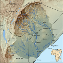
 Map of the Jubba/Shebelle drainage basin | |
| Native name | |
| Location | |
| Countries | |
| Physical characteristics | |
| Source | Ethiopian Highlands |
| • location | Robe Gerjeda, Ethiopia |
| • coordinates | 7°13′12″N 39°27′59″E / 7.2201°N 39.4665°E |
| • elevation | 2,326 m (7,631 ft) |
| Mouth | Jubba River (occasionally) |
• location | Jamame, Somalia |
• coordinates | 0°09′57″N 42°46′22″E / 0.1659°N 42.7727°E |
• elevation | 14 m (46 ft) |
| Length | 2,064 km (1,283 mi)[1] |
| Basin size | 298,253 km2 (115,156 sq mi)[1] |
| Discharge | |
| • location | Mouth[1] |
| • average | 71.2 m3/s (2,510 cu ft/s) |
| • minimum | 15.7 m3/s (550 cu ft/s) |
| • maximum | 158.7 m3/s (5,600 cu ft/s) |
| Basin features | |
| Progression | Jubba → Somali Sea |
| River system | Jubba River |
| Cities | Beledweyne, Jowhar |
| Population | 13,900,000[2] |
| Tributaries | |
| • left | Erer, Fafen |
| Waterbodies | Melka Wakena Reservoir |
The Shebelle River (Oromo: Laga Shabeellee, Somali: Webi Shabeelle, Amharic: እደላ, Italian: fiume Uebi Scebeli) also known historically as the Nile of Mogadishu,[3][4][5] begins in the highlands of Ethiopia, and then flows southeast into Somalia towards Mogadishu. Near Mogadishu, it turns sharply southwest, where it follows the coast. Below Mogadishu, the river becomes seasonal. During most years, the river dries up near the mouth of the Jubba River, while in seasons of heavy rainfall, the river actually reaches the Jubba and thus the ocean.
During periods of heavy rainfall in Ethiopia, the Shebelle River and the Jubba River merge, and their combined waters ultimately reach the Indian Ocean. However, in drier years, the Shebelle River diminishes and transforms into a series of wetlands and sandy plains to the northeast of the confluence with the Jubba. The Shebelle River has a total length of 1,820 km. The area surrounding the Shebeli River is inhabited by Somali people in the Somali Region of Ethiopia and Somali people in Somalia. In the lower basin of the river, agriculture has largely replaced the traditional nomadic herding lifestyle, and the cultivation of bananas along the southern stretches of the Shebeli and Jubba rivers contributes significantly to Somalia's export industry.[6]
- ^ a b c Lehner, Bernhard; Verdin, Kristine; Jarvis, Andy (2008-03-04). "New Global Hydrography Derived From Spaceborne Elevation Data". Eos, Transactions American Geophysical Union. 89 (10): 93–94. doi:10.1029/2008eo100001. ISSN 0096-3941.
- ^ Liu, L., Cao, X., Li, S., & Jie, N. (2023). GlobPOP: A 31-year (1990-2020) global gridded population dataset generated by cluster analysis and statistical learning (1.0) [Data set]. Zenodo. https://doi.org/10.5281/zenodo.10088105
- ^ Philips, John Edward (2006). Writing African History. University Rochester Press. p. 221. ISBN 978-1-58046-256-3.
- ^ Fage, J. D.; Oliver, Roland (1975). The Cambridge History of Africa. Cambridge University Press. p. 137. ISBN 978-0-521-20981-6.
- ^ ʻAlī, Abū al-Fidāʾ Ismāʻīl ibn (1848). Géographie d'Aboulféda (in French). Imprimerie nationale. pp. 232–233.
- ^ "Shebeli River | Kenya, Somalia & Ethiopia | Britannica". www.britannica.com. Retrieved 2023-12-02.