Back شوشونی، کالیفورنیا AZB Shoshone (Califòrnia) Catalan Шошони (Калифорни) CE Shoshone (California) Spanish Shoshone (Kalifornia) Basque شوشونی، کالیفرنیا Persian Shoshone (Californie) French شوشون (کاليفؤرنيا) GLK Shoshone (Kalifornija) Croatian Shoshone (California) Italian
Shoshone | |
|---|---|
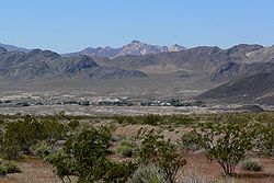
 View of Shoshone from the east | |
 Location in Inyo County and the state of California | |
| Coordinates: 35°58′23″N 116°16′16″W / 35.97306°N 116.27111°W | |
| Country | |
| State | |
| County | Inyo |
| Area | |
• Total | 28.711 sq mi (74.361 km2) |
| • Land | 28.711 sq mi (74.361 km2) |
| • Water | 0 sq mi (0 km2) 0% |
| Elevation | 2,595 ft (791 m) |
| Population | |
• Total | 22 |
| • Density | 0.77/sq mi (0.30/km2) |
| Time zone | UTC-8 (Pacific) |
| • Summer (DST) | UTC-7 (PDT) |
| ZIP code | 92384 |
| Area codes | 442/760 |
| FIPS code | 06-71680 |
| GNIS feature ID | 2408733[2] |
Shoshone is a census-designated place (CDP) in Inyo County, California, United States. The population was 22 at the 2020 census, down from 31 at the 2010 census.[3]
The town was founded in 1910. Although small, it is notable as a southern gateway to Death Valley National Park; in addition to being a junction of roads leading from Baker, California and Pahrump, Nevada, it has the last services available before the Furnace Creek area in the park. The commercial district of the town, including a post office, gas station, restaurant, bar and coffee house, is just north of the southern intersection of California State Routes 127 and 178.
Shoshone has a single 2,380-foot (730 m) airstrip across SR 127 from the commercial district. It is open to the public and gets about 58 flights per month.[4]
Shoshone, California, has a history as a railroad town and rich mining district.[5]
- ^ "2010 Census Gazetteer Files - Places - California". United States Census Bureau. Retrieved March 26, 2015.
- ^ a b U.S. Geological Survey Geographic Names Information System: Shoshone, California
- ^ "Explore Census Data". data.census.gov. Retrieved August 8, 2022.
- ^ "L61 - Shoshone Airport". AirNav. November 23, 2006. Retrieved December 8, 2006.
- ^ "Shoshone Village - Shoshone, California". shoshonevillage.com. Retrieved June 17, 2019.
