Back سييرا مادري الغربية Arabic Западна Сиера Мадре Bulgarian Sierra Madre Occidental Breton Sierra Madre Occidental Catalan Sierra Madre Occidental CEB Sierra Madre Occidental Czech Sierra Madre Occidental Welsh Sierra Madre Occidental German Okcidenta Patrinmontaro Esperanto Sierra Madre Occidental Spanish
| Sierra Madre Occidental | |
|---|---|
 Río Grande de Santiago winding through the Sierra Madre Occidental, forming part of the border between Nayarit and Jalisco. | |
| Highest point | |
| Peak | Cerro Mohinora |
| Elevation | 10,863 ft (3,311 m) |
| Coordinates | 25°57′22″N 107°2′52″W / 25.95611°N 107.04778°W |
| Dimensions | |
| Length | 932 mi (1,500 km) NW × SE |
| Width | 150 mi (240 km) W × E |
| Geography | |
| Country | Mexico |
| State(s) | Sonora, Chihuahua, Sinaloa, Durango, Zacatecas, Nayarit, Jalisco, Aguascalientes |
| Region | Northwestern Mexico |
| Borders on | |
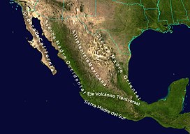
The Sierra Madre Occidental is a major mountain range system of the North American Cordillera, that runs northwest–southeast through northwestern and western Mexico, and along the Gulf of California. The Sierra Madre is part of the American Cordillera, a chain of mountain ranges (cordillera) that consist of an almost continuous sequence that form the western "sounds" of North America, Central America, South America, and West Antarctica.
