Back Sinus Sabaeus (Gradfeld) German Sinus Sabaeus (cuadrángulo) Spanish Quadrangle de Sinus Sabaeus French साइनस सेबेयस चतुष्कोण Hindi Sinus Sabaeus (Gradsecteur) LB Quadrângulo de Sinus Sabaeus Portuguese Cuadràngoło de Sinus Sabaeus VEC 示巴湾区 Chinese
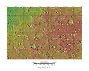
 Map of Sinus Sabaeus quadrangle from Mars Orbiter Laser Altimeter (MOLA) data. The highest elevations are red and the lowest are blue. | |
| Coordinates | 15°00′S 337°30′W / 15°S 337.5°W |
|---|---|

The Sinus Sabaeus quadrangle is one of a series of 30 quadrangle maps of Mars used by the United States Geological Survey (USGS) Astrogeology Research Program. It is also referred to as MC-20 (Mars Chart-20).[1] The Sinus Sabaeus quadrangle covers the area from 315° to 360° west longitude and 0° to 30° degrees south latitude on Mars. It contains Schiaparelli, a large, easily visible crater that sits close to the equator. The Sinus Sabaeus quadrangle contains parts of Noachis Terra and Terra Sabaea.
The name comes from an incense-rich location south of the Arabian peninsula (the Gulf of Aden).[2]