Back غابة سونيان ARZ Bosc de Soignes Catalan Forêt de Soignes CEB Sonienwald German Σονιακός δρυμός Greek Sonia Arbaro Esperanto Bosque de Soignes Spanish Forêt de Soignes French Soignes-i erdő Hungarian Foresta di Soignes Italian
| Sonian Forest Dutch: Zoniënwoud French: Forêt de Soignes | |
|---|---|
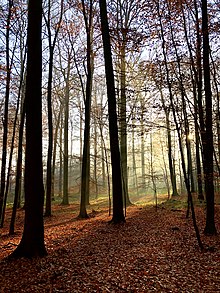
 Autumn light in the Sonian Forest | |
| Geography | |
| Location | Belgium |
| Coordinates | 50°46′N 4°25′E / 50.767°N 4.417°E |
| Area | 4,421 hectares (10,920 acres) |
The Sonian Forest or Sonian Wood (Dutch: Zoniënwoud, pronounced [ˈzoːnijə(ɱ)ʋʌut]; French: Forêt de Soignes, pronounced [fɔ.ʁɛ d(ə) swaɲ]) is a 4,421-hectare (10,920-acre) forest at the south-eastern edge of Brussels, Belgium. It is connected to the Bois de la Cambre/Ter Kamerenbos, an urban public park which enters the city up to 4 kilometres (2.5 mi) from the city centre.
The forest lies in the Flemish municipalities of Sint-Genesius-Rode, Hoeilaart, Overijse, and Tervuren, in the Brussels-Capital Region municipalities of Uccle, Watermael-Boitsfort, Auderghem, and Woluwe-Saint-Pierre, and in the Walloon towns of La Hulpe and Waterloo. Thus, it stretches out over the three Belgian Regions. It is maintained by Flanders (56%), Brussels (38%), and Wallonia (6%). There are some contiguous tracts of privately held forest and the Kapucijnenbos, the "Capuchin Wood", which belongs to the Royal Trust.
As of 2017, parts of the Sonian Forest have been inscribed as a UNESCO World Heritage Site, the only Belgian component to the multinational inscription 'Primeval Beech Forests of the Carpathians and Other Regions of Europe', because of their undisturbed nature and testimony to the ecological processes governing forests in Europe since the Last Glacial Period.[1]
- ^ "Ancient and Primeval Beech Forests of the Carpathians and Other Regions of Europe". UNESCO World Heritage Centre. United Nations Educational, Scientific, and Cultural Organization. Retrieved 3 September 2022.