Back مقاطعة سونوما (كاليفورنيا) Arabic مقاطعة سونوما ، كاليفورنيا ARZ Sonoma qraflığı (Kaliforniya) Azerbaijani Sonoma County, Kalifornien BAR Санома (акруга) Byelorussian Сонома Bulgarian সোনোমা কাউন্টি, ক্যালিফোর্নিয়া BPY Comtat de Sonoma Catalan Сонома (гуо, Калифорни) CE Sonoma County CEB
Sonoma County, California | |
|---|---|
| County of Sonoma | |
| Motto(s): "Agriculture, Industry, Recreation" | |
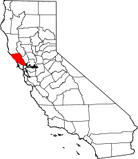
 Interactive map of Sonoma County | |
 Location in the state of California | |
| Coordinates: 38°31′N 122°56′W / 38.51°N 122.93°W | |
| Country | |
| State | |
| Region | San Francisco Bay Area |
| Incorporated | February 18, 1850[1] |
| Named for | the city of Sonoma |
| County seat (and largest city) | Santa Rosa |
| Government | |
| • Type | Council–Administrator |
| • Body | Sonoma County Board of Supervisors |
| • Chair | Lynda Hopkins |
| • Vice Chair | Rebecca Hermosillo |
| • Chair Pro Tem | James Gore |
| • Board of Supervisors[2] | Supervisors
|
| • County Administrator | Sheryl Bratton |
| Area | |
• Total | 1,768 sq mi (4,580 km2) |
| • Land | 1,576 sq mi (4,080 km2) |
| • Water | 192 sq mi (500 km2) |
| Highest elevation | 4,483 ft (1,366 m) |
| Population (2020) | |
• Total | 488,863 |
| • Density | 280/sq mi (110/km2) |
| GDP | |
| • Total | $36.877 billion (2022) |
| Time zone | UTC−8 (Pacific Time Zone) |
| • Summer (DST) | UTC−7 (Pacific Daylight Time) |
| Area code | 707 |
| FIPS code | 06-097 |
| GNIS feature ID | 1657246 |
| Congressional districts | 2nd, 4th |
| Website | sonomacounty |
Sonoma County (/səˈnoʊmə/ ⓘ) is a county located in the U.S. state of California. As of the 2020 United States Census, its population was 488,863.[5] Its seat of government and largest city is Santa Rosa.[6]
Sonoma County comprises the Santa Rosa-Petaluma Metropolitan Statistical Area, which is part of the San Jose-San Francisco-Oakland, CA Combined Statistical Area. It is the northernmost county in the nine-county San Francisco Bay Area region.
In California's Wine Country region, which also includes Napa, Mendocino, and Lake counties, Sonoma County is the largest producer. It has nineteen approved American Viticultural Areas and more than 350 wineries. The voters have twice approved open space initiatives[7] that have provided funding for public acquisition of natural areas, preserving forested areas, coastal habitat, and other open space. More than 8.4 million tourists visit each year, spending more than $1 billion in 2016.
Sonoma County is a leading producer of hops, grapes, prunes, and apples, as well as dairy and poultry products,[8] largely due to the extent of available, fertile agricultural land in addition to the abundance of high-quality water for irrigation. Agriculture is largely divided between two nearly monocultural uses: grapes and pasturage.
- ^ "Chronology". California State Association of Counties. Retrieved February 6, 2015.
- ^ "Board of Supervisors". Sonomacounty.ca.gov.
- ^ "Cobb Mountain-Southwest Peak". Peakbagger.com. Retrieved February 4, 2015.
- ^ "Gross Domestic Product: All Industries in Sonoma County, CA". Federal Reserve Economic Data. Federal Reserve Bank of St. Louis.
- ^ "Sonoma County, California". United States Census Bureau. Retrieved January 30, 2022.
- ^ "Find a County". National Association of Counties. Archived from the original on May 31, 2011. Retrieved June 7, 2011.
- ^ "Sonoma County Agricultural Preservation and Open Space District". Sonoma County. Archived from the original on December 31, 2006. Retrieved July 17, 2014.
- ^ "Sonoma County Flood Control and Water Conservation District: History". Sonoma County Water Agency. Archived from the original on October 2, 2009.


