Back Su Tyneside Breton South Tyneside Catalan South Tyneside CEB De Tyneside Welsh South Tyneside German South Tyneside Spanish تاینساید جنوبی Persian South Tyneside Finnish South Tyneside French South Tyneside FRR
Metropolitan Borough of South Tyneside | |
|---|---|
 | |
| Motto: Always Ready | |
 South Tyneside shown within Tyne and Wear | |
| Coordinates: 54°57′32″N 1°26′17″W / 54.959°N 1.438°W | |
| Sovereign state | United Kingdom |
| Country | England |
| Region | North East |
| Ceremonial county | Tyne and Wear |
| City region | North East |
| Incorporated | 1 April 1974 |
| Named for | River Tyne |
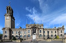
| Administrative HQ | South Shields Town Hall |
| Government | |
| • Type | Metropolitan borough |
| • Body | South Tyneside Council |
| • Executive | Leader and cabinet |
| • Control | Labour |
| • Leader | Tracey Dixon (L) |
| • Mayor | Fay Cunningham |
| • MPs | 2 MPs |
| Area | |
• Total | 25 sq mi (64 km2) |
| • Rank | 231st |
| Population (2022)[3] | |
• Total | 148,667 |
| • Rank | 148th |
| • Density | 5,980/sq mi (2,308/km2) |
| Ethnicity (2021) | |
| • Ethnic groups | |
| Religion (2021) | |
| • Religion | List
|
| Time zone | UTC+0 (GMT) |
| • Summer (DST) | UTC+1 (BST) |
| Postcode areas | |
| Dialling codes | 0191 |
| ISO 3166 code | GB-STY |
| GSS code | E08000023 |
| Website | southtyneside |
South Tyneside is a metropolitan borough in the metropolitan county of Tyne and Wear, England. It is bordered by all four other boroughs in Tyne and Wear: Gateshead to the west, Sunderland in the south, North Tyneside to the north and Newcastle upon Tyne to the north-west. The border county of Northumberland lies further north. The borough was formed on 1 April 1974 by the merger of the County Borough of South Shields with the municipal borough of Jarrow and the urban districts of Boldon and Hebburn from County Durham.
Part of the Tyneside conurbation, the sixth largest in the United Kingdom, South Tyneside has a geographical area of 24.88 sq mi (64.4 km2) and an estimated population of 153,700 (mid-year 2010), measured at the 2011 Census as 148,127.[5] It is bordered to the east by the North Sea and to the north by the River Tyne. A Green Belt of 9.13 sq mi (23.6 km2) is at its southern boundary.

The main administrative centre and largest town is South Shields. Other riverside towns are Jarrow and Hebburn, while the villages of Cleadon, Whitburn and The Boldons border the South Tyneside green belt, with Wearside to the south at Sunderland.
South Tyneside is represented by two Members of Parliament in two constituencies: South Shields (including Whitburn) and Jarrow and Gateshead East (which also serves Hebburn, the urban fringe villages, and the eastern parts of Gateshead).
- ^ "Councillors and committee meetings". South Tyneside Council. Retrieved 14 July 2024.
- ^ "Mid-Year Population Estimates, UK, June 2022". Office for National Statistics. 26 March 2024. Retrieved 3 May 2024.
- ^ "Mid-Year Population Estimates, UK, June 2022". Office for National Statistics. 26 March 2024. Retrieved 3 May 2024.
- ^ a b UK Census (2021). "2021 Census Area Profile – South Tyneside Local Authority (E08000023)". Nomis. Office for National Statistics. Retrieved 14 July 2024.
- ^ "Local Authority population 2011". Retrieved 6 July 2015.
