Back المقاطعة الجنوبية (هونغ كونغ) Arabic Southern (distrito) CEB Southern District (Hongkong) German Distrito Sur (Hong Kong) Spanish Hegoaldeko barrutia (Hong Kong) Basque منطقه جنوبی، هنگ کنگ Persian Southern (district) French Nàm-khî (Hiông-kóng) HAK דרום הונג קונג HE Déli kerület Hungarian
Southern
南區 | |
|---|---|
| Southern District | |
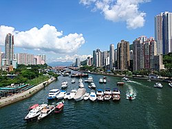
 Day view of Aberdeen in the Southern District | |
 | |
 Location of Southern District within Hong Kong | |
| Coordinates: 22°14′50″N 114°09′32″E / 22.24725°N 114.15884°E | |
| Statutory-defined area | Hong Kong |
| Region | Hong Kong (special administrative region) |
| Country | China |
| Constituencies | 17[needs update] |
| Government | |
| • District Council Chairman | vacant |
| • District Council Vice-Chairman | Paul Zimmerman[needs update] |
| • District Officer | Cheng Kong-Chung |
| Area | |
• Total | 38.8 km2 (15.0 sq mi) |
| Population | |
• Total | 274,994 |
| • Density | 7,100/km2 (18,000/sq mi) |
| Time zone | UTC+8 (Hong Kong Time) |
| Largest neighbourhood by population | Ap Lei Chau (86,752 – 2016 est)[2] |
| Location of district office and district council | 3 Aberdeen Praya Road, Staunton Creek |
| Website | Southern District Council |
| Southern District | |||||||||||||||
|---|---|---|---|---|---|---|---|---|---|---|---|---|---|---|---|
| Traditional Chinese | 南區 | ||||||||||||||
| Simplified Chinese | 南区 | ||||||||||||||
| Cantonese Yale | Nàahm kēui | ||||||||||||||
| Literal meaning | Southern District | ||||||||||||||
| |||||||||||||||
The Southern District is one of the 18 districts of Hong Kong. It is located in the southern part of Hong Kong Island and the largest part of the island. It had a population of 274,994 in 2016.[3]
- ^ "District Profiles | 2016 Population" (in English and Chinese). Census and Statistics Department, Hong Kong Government. 2016. Retrieved 26 May 2020.
- ^ District Profiles, Hong Kong Government, 8 December 2017, retrieved 15 April 2020
- ^ "District Profiles | 2016 Population By-census". www.bycensus2016.gov.hk. Retrieved 13 January 2020.