Back نهر سپوكان ARZ Спакан Byelorussian Spokane River German Río Spokane Spanish Spokane'i jõgi Estonian Spokane (rivière) French Spokane (fiume) Italian Spokanų upė Lithuanian Spokane (rivier) Dutch Спокан (река) Russian
| Spokane River | |
|---|---|
 Spokane River in Lincoln County, 1909 | |
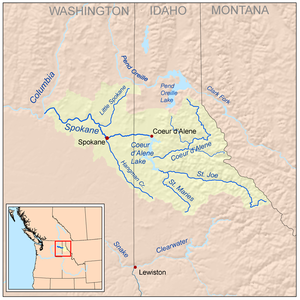
 Spokane River watershed | |
| Etymology | Spokane tribe, the "sun people"[1] |
| Location | |
| Country | United States |
| State | Washington, Idaho |
| County | Kootenai, Spokane, Stevens, Lincoln |
| Physical characteristics | |
| Source | Lake Coeur d'Alene |
| • location | Kootenai County, Idaho |
| • coordinates | 47°40′41″N 117°07′34″W / 47.67806°N 117.12611°W[2] |
| • elevation | 1,994 ft (608 m)[3] |
| Mouth | Columbia River at |
• location | Lake Roosevelt, Washington |
• coordinates | 47°53′38″N 118°20′03″W / 47.89389°N 118.33417°W[2] |
• elevation | 1,293 ft (394 m)[2] |
| Length | 111 mi (179 km)[4] |
| Basin size | 6,020 sq mi (15,600 km2)[5] |
| Discharge | |
| • location | mouth, max and min at Long Lake Dam[5] |
| • average | 7,946 cu ft/s (225.0 m3/s)[5] |
| • minimum | 90 cu ft/s (2.5 m3/s) |
| • maximum | 49,700 cu ft/s (1,410 m3/s) |
| Basin features | |
| Progression | Columbia River → Pacific Ocean |
| River system | Columbia River |
| Tributaries | |
| • left | Cable Creek, Latah Creek, Deep Creek |
| • right | Little Spokane River |
The Spokane River is a tributary of the Columbia River, approximately 111 miles (179 km) long, in northern Idaho and eastern Washington in the United States. It drains a low mountainous area east of the Columbia, passing through the Spokane Valley and the city of Spokane, Washington.
- ^ Phillips, James W. (1971). Washington State Place Names. University of Washington Press. pp. 134–135. ISBN 0-295-95498-1.
- ^ a b c "Spokane River". Geographic Names Information System (GNIS). United States Geological Survey (USGS). September 10, 1979. Retrieved October 17, 2008.
- ^ Source elevation derived from Google Earthsearch using GNIS source coordinates.
- ^ "Online Topographic Maps from the United States Geological Survey". TopoQuest. Retrieved October 19, 2008.
- ^ a b c Benke, Arthur C. & Cushing, Colbert E. (2005). Rivers of North America. Academic Press. p. 650. ISBN 978-0-12-088253-3. Retrieved 2008-10-16.