Back سانت كلير Arabic سانت كلير ARZ سنت. کلایر، میشیقان AZB Сент-Клер (Мичиган) CE Saint Clair (lungsod sa Tinipong Bansa, Michigan) CEB St. Clair, Michigan Welsh St. Clair (Míchigan) Spanish St. Clair (Michigan) Basque سنت. کلایر، میشیگان Persian St. Clair (Michigan) French
St. Clair | |
|---|---|
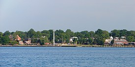
 View from across the St. Clair River | |
| Nickname: Saint Clair | |
 Location within St. Clair County | |
| Coordinates: 42°49′23″N 82°29′32″W / 42.82306°N 82.49222°W | |
| Country | United States |
| State | Michigan |
| County | St. Clair |
| Government | |
| • Type | Council–manager |
| • Mayor | Bill Cedar |
| Area | |
• Total | 3.62 sq mi (9.37 km2) |
| • Land | 2.94 sq mi (7.61 km2) |
| • Water | 0.68 sq mi (1.75 km2) |
| Elevation | 584 ft (178 m) |
| Population (2020) | |
• Total | 5,464 |
| • Density | 1,858.50/sq mi (717.64/km2) |
| Time zone | UTC-5 (Eastern (EST)) |
| • Summer (DST) | UTC-4 (EDT) |
| ZIP code(s) | 48079 |
| Area code | 810 |
| FIPS code | 26-70680[2] |
| GNIS feature ID | 1624881[3] |
| Website | Official website |
St. Clair is a city in St. Clair County in the eastern "Thumb" of the U.S. state of Michigan. The population was 5,485 at the 2010 census. The city is located on the St. Clair River near the southeast corner of St. Clair Township.
- ^ "2020 U.S. Gazetteer Files". United States Census Bureau. Retrieved May 21, 2022.
- ^ "U.S. Census website". United States Census Bureau. Retrieved January 31, 2008.
- ^ "US Board on Geographic Names". United States Geological Survey. October 25, 2007. Retrieved January 31, 2008.
