Back استنواسمویر AZB Stenhousemuir Welsh Stenhousemuir German Stenhousemuir Spanish Stenhousemuir Basque استنواسمویر Persian Stenhousemuir French Featha Thaigh nan Clach Irish Stenhousemuir Scots/Gaelic Stenhousemuir Italian
Stenhousemuir
| |
|---|---|
 Larbert and Stenhousemuir | |
Location within the Falkirk council area | |
| Area | 2+3⁄16 sq mi (5.7 km2) |
| Population | 9,620 (2022)[1] |
| • Density | 4,810/sq mi (1,860/km2) |
| OS grid reference | NS875831 |
| • Edinburgh | 24+1⁄2 mi (39 km) ESE |
| • London | 347 mi (558 km) SSE |
| Council area | |
| Lieutenancy area | |
| Country | Scotland |
| Sovereign state | United Kingdom |
| Post town | LARBERT |
| Postcode district | FK5 |
| Dialling code | 01324 |
| Police | Scotland |
| Fire | Scottish |
| Ambulance | Scottish |
| UK Parliament | |
| Scottish Parliament | |
| Website | falkirk.gov.uk |
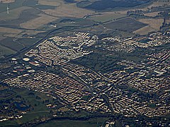
Stenhousemuir (/ˌstɛnaʊsˈmjʊər/; Scottish Gaelic: Featha Thaigh nan Clach) is a town in the Central Lowlands of Scotland. It lies within the Falkirk council area of Scotland. The town is two miles (three kilometres) north-northwest of Falkirk and directly adjoins to Larbert in the west, where the nearest rail access is located. The villages of Carron and Carronshore adjoin Stenhousemuir to the east but to a lesser extent. Historically, Stenhousemuir lies with the historic county of Stirlingshire. At the 2001 census it showed that it had a resident population of 10,351[2] but according to a 2009 estimate this was revised to around 10,190 residents.[3] The combined population of the four localities in 2011 was 24,722,[4] representing about 15% of the Falkirk council area total.
In 2008, a £15 million town centre development scheme was completed and opened which provided a new civic square, a library and large retailing outlets for Stenhousemuir.[5]
- ^ "Mid-2020 Population Estimates for Settlements and Localities in Scotland". National Records of Scotland. 31 March 2022. Retrieved 31 March 2022.
- ^ No 3 - 2001 Census Population of settlements and wards (PDF). www.falkirk.gov.uk. Archived from the original (PDF) on 3 June 2011. Retrieved 1 May 2011.
- ^ Facts about Falkirk - Major Settlement Population (2009) (PDF). www.falkirk.gov.uk. Archived from the original (PDF) on 28 June 2011. Retrieved 1 May 2011.
- ^ "Insight 2011 Census, No. 6 - Settlement Population and Household Estimates" (PDF). Falkirk Council. Retrieved 4 January 2020.
- ^ Stenhousemuir - Falkirk. www.scottish-places.info. Retrieved 1 May 2011.
