Back Gorsaf reilffordd Stevenage Welsh Stazzion de Stevenage LMO Station Stevenage Dutch סטיווענידזש באן סטאנציע YI
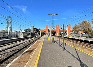
 The station in November 2021 looking north, with the new platform 5 on the far left | |||||
| General information | |||||
| Location | Stevenage, Borough of Stevenage England | ||||
| Grid reference | TL234241 | ||||
| Owned by | Network Rail | ||||
| Managed by | Great Northern | ||||
| Platforms | 5 | ||||
| Connections | Local Buses | ||||
| Other information | |||||
| Station code | SVG | ||||
| Classification | DfT category C1 | ||||
| History | |||||
| Opened | 23 July 1973 | ||||
| Key dates | |||||
| 8 August 1850 | Original station opened by GNR | ||||
| 22 July 1973 | Station closed | ||||
| 23 July 1973 | Relocated 73 chains (1.5km) south to present location and opened by BR | ||||
| 29 September 1973 | Officially opened by Shirley Williams MP | ||||
| Passengers | |||||
| 2019/20 | |||||
| Interchange | | ||||
| 2020/21 | |||||
| Interchange | | ||||
| 2021/22 | |||||
| Interchange | | ||||
| 2022/23 | |||||
| Interchange | | ||||
| 2023/24 | |||||
| Interchange | | ||||
| |||||
Stevenage railway station serves the town of Stevenage in Hertfordshire, England. The station is around 27.6 miles (44.4 km) north of London King's Cross on the East Coast Main Line. The station lies just to the north of Langley junction, a grade separated junction where the Hertford Loop Line diverges from the East Coast Main Line; the two lines re-converge at Alexandra Palace in London's northern suburbs.[1]
Stevenage is served and managed by Govia Thameslink Railway, which operates stopping services southbound to King’s Cross, Brighton, Gatwick Airport and Moorgate; northbound services connect to Cambridge and Peterborough. It is also served frequently by London North Eastern Railway, which operates non-stopping services southbound to King's Cross and northbound to York, Leeds and Edinburgh Waverley. Hull Trains and Lumo operate very limited services from the station.
The present station, built by British Rail, was opened for services on 23 July 1973.[2] It was officially opened on 26 September 1973 by Shirley Williams, then MP for Stevenage;[nb 1] this replaced the previous station which was sited 73 chains (1,500 m) to the north and further away from the centre of the new town.[1]
- ^ a b Yonge, John (September 2006) [1994]. Jacobs, Gerald (ed.). Railway Track Diagrams 2: Eastern (3rd ed.). Bradford on Avon: Trackmaps. map 15B. ISBN 0-9549866-2-8.
- ^ Butt, R.V.J. (1995). The Directory of Railway Stations. Yeovil: Patrick Stephens Ltd. p. 219. ISBN 1-85260-508-1. R508.
Cite error: There are <ref group=nb> tags on this page, but the references will not show without a {{reflist|group=nb}} template (see the help page).