| Stony Creek | |
|---|---|
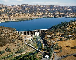
 Stony Gorge Dam on Stony Creek, near Elk Creek | |
 Map of the Stony Creek drainage basin | |
| Location | |
| Country | United States |
| State | California |
| Physical characteristics | |
| Source | California Coast Ranges |
| • location | Mendocino National Forest, Colusa County |
| • coordinates | 39°22′45″N 122°38′50″W / 39.37917°N 122.64722°W[1] |
| • elevation | 1,457 ft (444 m) |
| Mouth | Sacramento River |
• location | near Hamilton City, Glenn County |
• coordinates | 39°40′38″N 121°58′23″W / 39.67722°N 121.97306°W[1] |
• elevation | 108 ft (33 m) |
| Length | 73.5 mi (118.3 km)[2] |
| Basin size | 777 sq mi (2,010 km2)[2] |
| Discharge | |
| • location | near Fruto, above Black Butte Lake[3] |
| • average | 646 cu ft/s (18.3 m3/s)[4] |
| • minimum | 0.018 cu ft/s (0.00051 m3/s) |
| • maximum | 40,200 cu ft/s (1,140 m3/s) |
| Basin features | |
| Tributaries | |
| • left | North Fork Stony Creek, Grindstone Creek |
| • right | Middle Fork Stony Creek, Little Stony Creek |
Stony Creek is a 73.5-mile (118.3 km)-long[2] tributary of the Sacramento River in Northern California. It drains a watershed of more than 700 square miles (1,800 km2) on the west side of the Sacramento Valley in Glenn, Colusa, Lake and Tehama Counties.
Originating on the eastern slope of the Coast Ranges, Stony Creek flows north through an extensive series of foothill valleys before turning east across the Sacramento Valley to its confluence with the Sacramento River, about 5 miles (8.0 km) west-southwest of Chico. Stony Creek is the second largest tributary to the west side of the Sacramento River; only Cottonwood Creek is larger. Stony Creek is an important source of water for agriculture in the Orland area. The creek has native rainbow trout and historically had significant ocean-going runs of steelhead.
Stony Creek was named for the large amount of rocks and sediments it once washed down from the mountains during floods. Today, most of the sediment is trapped behind Black Butte Dam, a flood-control structure built in 1963.[5] It is labeled on some maps as "Stoney Creek" or "Stone Creek" and was historically known as the Capay River.[6]
- ^ a b "Stony Creek". Geographic Names Information System. United States Geological Survey, United States Department of the Interior. 1981-01-19. Retrieved 2017-10-22.
- ^ a b c "USGS National Hydrography Dataset high-resolution flowline data via National Map Viewer". U.S. Geological Survey. Retrieved 2017-09-24.
- ^ "USGS Gage #11387000 Stony Creek near Fruto, CA". National Water Information System. U.S. Geological Survey. 1901–1978. Retrieved 2017-10-22.
- ^ "USGS Gage #11387000 Stony Creek near Fruto, CA". National Water Information System. U.S. Geological Survey. 1901–1978. Retrieved 2017-10-22.
- ^ H.T. Harvey & Associates (2007-02-23). "Stony Creek Watershed Assessment, Volume 1: Lower Stony Creek Watershed Analysis" (PDF). Glenn County Resource Conservation District. Retrieved 2017-10-22.
- ^ Kyle et al. 2002, p. 98.
