Back Municipio Sucre (munisipyo sa Miranda) CEB Municipio Sucre (Miranda) Spanish Sucre (Miranda) French Sucre (Miranda) Italian スクレ市 (ミランダ州) Japanese სუკრეს მუნიციპალიტეტი (მირანდა) Georgian 수크레시 (미란다주) Korean Sucre (Miranda) Dutch Sucre (Miranda) Portuguese Sucre, Miranda SCO
Sucre Municipality
Municipio Sucre | |
|---|---|
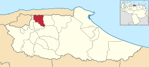
 Location in Miranda | |
| Coordinates: 10°28′19″N 66°45′39″W / 10.4719°N 66.7608°W | |
| Country | |
| State | Miranda |
| Founded | February 17, 1621 |
| Incorporated | 1989 |
| Municipal seat | Petare |
| Government | |
| • Mayor | José Vicente Rangel Ávalos (PSUV) |
| Area | |
• Total | 199.0 km2 (76.8 sq mi) |
| Population (2016) | |
• Total | 691,317 |
| • Density | 3,500/km2 (9,000/sq mi) |
| Time zone | UTC−4 (VET) |
| Area code(s) | 0212 |
| Website | Official website |
Sucre Municipality is one of the 21 municipalities (municipios) that makes up the Venezuelan state of Miranda and one of five the municipalities that make up the Metropolitan District of Caracas. According to a 2016 population estimate by the National Institute of Statistics of Venezuela, the municipality has a population of 691,317.[1] The parish of Petare is the municipal seat of the Sucre Municipality.[2]
- ^ http://www.ine.gob.ve/sintesisestadistica/estados/miranda/cuadros/Poblacion6.xls[permanent dead link]
- ^ "Archived copy". Archived from the original on 2007-12-21. Retrieved 2008-03-22.
{{cite web}}: CS1 maint: archived copy as title (link)


