Back Салливан (Нью-Йорк) CE Sullivan (New York) German Sullivan (Nueva York) Spanish Sullivan (New York) Basque Sullivan (New York) French Sullivan, New York HT Sullivan (Nowy Jork) Polish Салливан (Нью-Йорк) Tatar Салліван (Нью-Йорк) Ukrainian Sullivan (New York) Uzbek
Parts of this article (those related to demographics) need to be updated. (April 2017) |
43°4′N 75°52′W / 43.067°N 75.867°W
Sullivan, New York | |
|---|---|
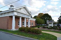
 Sullivan Free Library | |
| Coordinates: 43°4′N 75°52′W / 43.067°N 75.867°W | |
| Country | United States |
| State | New York |
| County | Madison |
| Government | |
| • Type | Town Council |
| • Town Supervisor | Thomas G. Daviau (R) [1] |
| • Town Council | Members' List |
| Area | |
• Total | 73.34 sq mi (189.9 km2) |
| • Land | 73.13 sq mi (189.4 km2) |
| • Water | 0.21 sq mi (0.5 km2) |
| Elevation | 410 ft (120 m) |
| Population | |
• Total | 14,794 |
| • Density | 202.3/sq mi (78.1/km2) |
| Time zone | UTC-5 (Eastern (EST)) |
| • Summer (DST) | UTC-4 (EDT) |
| ZIP Codes | 13030 (Bridgeport) 13037 (Chittenango) 13032 (Canastota) 13035 (Cazenovia) 13082 (Kirkville) 13104 (Manlius) |
| Area code | 315 |
| FIPS code | 36-053-71993 |
| GNIS feature ID | 0979535 |
| Website | www |
Sullivan is a town in Madison County, New York, United States. The population was 14,794 at the 2020 census.[3] The town is named after Revolutionary War general John Sullivan.
- ^ "Thomas G. Daviau | Madison County, NY".
- ^ "2024 U.S. Gazetteer Files: New York". United States Census Bureau. Retrieved January 28, 2025.
- ^ a b "P1. Race – Sullivan town, New York: 2020 DEC Redistricting Data (PL 94-171)". U.S. Census Bureau. Retrieved January 28, 2025.

