Back سلطنة سولك Arabic Sulu sultanlığı Azerbaijani سولو سولطانلیغی AZB Sultanato nin Sulu BCL Сулу (султанат) Byelorussian Kesultanan Sulu BEW সুলুর সালতানাত Bengali/Bangla Sultanat de Sulu Catalan Sultanat von Sulu German Σουλτανάτο του Σούλου Greek
Sultanate of Sulu كسلطانن سن سوڬ Kasultanan sin Sūg | |||||||||||||||||||
|---|---|---|---|---|---|---|---|---|---|---|---|---|---|---|---|---|---|---|---|
| |||||||||||||||||||
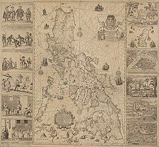
 Map showing the extent of the Sultanate of Sulu in 1845, with Northeast Borneo lowlands being under its nominal control. | |||||||||||||||||||
| Status | Bruneian vassal (1457–1578) Sovereign state (1578–1851) Spanish protectorate (1851–1899) U.S. protectorate (1899–1915) | ||||||||||||||||||
| Capital | |||||||||||||||||||
| Common languages | Tausug, Sama–Bajau, Malay | ||||||||||||||||||
| Religion | Sunni Islam | ||||||||||||||||||
| Government | Monarchy | ||||||||||||||||||
| Sultan | |||||||||||||||||||
• 1457–1480 (first) | Sharif ul-Hāshim | ||||||||||||||||||
• 1894–1915 (last) | Jamalul Kiram II | ||||||||||||||||||
| History | |||||||||||||||||||
• Established | 1457 | ||||||||||||||||||
• Temporal power ceded to the United States | 22 March 1915 | ||||||||||||||||||
| Currency | Philippine Peso or barter for local use[3] | ||||||||||||||||||
| |||||||||||||||||||
| Today part of | |||||||||||||||||||
The Sultanate of Sulu (Tausug: Kasultanan sin Sūg; Malay: Kesultanan Suluk; Filipino: Kasultanan ng Sulu) was a Sunni Muslim state[note 1] that ruled the Sulu Archipelago, coastal areas of Zamboanga City and certain portions of Palawan in the today's Philippines, alongside parts of present-day Sabah and North Kalimantan in north-eastern Borneo.
| History of the Philippines |
|---|
 |
| Timeline |
|
|
| Part of a series on the |
| Pre-colonial history of the Philippines |
|---|
 |
| See also: History of the Philippines |
The sultanate was founded either on 17 November 1405 or 1457[5][note 2] by Johore-born explorer and Sunni religious scholar Sharif ul-Hashim. Paduka Mahasari Maulana al Sultan Sharif ul-Hashim became his full regnal name; Sharif-ul Hashim is his abbreviated name. He settled in Buansa, Sulu.[9][10] The sultanate gained its independence from the Bruneian Empire in 1578.[11]
At its peak, it stretched over the islands that bordered the western peninsula of Zamboanga in Mindanao in the east to Palawan in the north. It also covered areas in the northeast of Borneo, stretching from Marudu Bay, Sabah[12][13] to Tepian, Sembakung subdistrict, North Kalimantan.[14][15] Another source stated the area included stretched from Kimanis Bay, which also overlaps with the boundaries of the Bruneian Sultanate.[16] Following the arrival of western powers such as the Spanish, the British, the Dutch, French, Germans, the Sultan thalassocracy and sovereign political powers were relinquished by 1915 through an agreement that was signed with the United States.[17][18][19][20] In 1974, the Filipino government officially recognised the historical territories of the Sultanate and the head of the royal house as the Sultan of Sulu.[21]
In Kakawin Nagarakretagama, the Sultanate of Sulu is referred to as Solot, one of the countries in the Tanjungnagara archipelago (Kalimantan-Philippines), which is one of the areas that is under the influence of the mandala area of the Majapahit kingdom in the archipelago.
- ^ Saleeby (1870–1935), Najeeb Mitry. "The History of Sulu". www.gutenberg.org.
{{cite web}}: CS1 maint: numeric names: authors list (link) - ^ C, Josiah, Historical Timeline of The Royal Sultanate of Sulu Including Related Events of Neighboring Peoples, NIU, archived from the original on 29 April 2012, retrieved 21 December 2010.
- ^ "11 scams used by Filipinos before and during the Spanish Era". The Kahimyang Project. 5 November 2011.
- ^ Scott 1994, p. 177.
- ^ Abinales & Amoroso 2005, p. 44
- ^ Philippine Almanac & Handbook of Facts. 1977.
- ^ Usman, Edd (10 February 2010). "Heirs of Sulu Sultanate urged to attend general convention". Manila Bulletin. Archived from the original on 14 June 2012. Retrieved 21 December 2010.
- ^ Cavendish 2007, p. 1178.
- ^ Abdurahman, Habib Jamasali Sharief Rajah Bassal (2002). The Sultanate of Sulu: Their Dominion. University of Michigan: Astoria Print. & Publishing Company. p. 88. ISBN 9789719262701.
- ^ Cite error: The named reference
Genealogy of Sultan Sharif Ul-Hashim of Sulu Sultanatewas invoked but never defined (see the help page). - ^ Ring, Trudy; Salkin, Robert M.; La Boda, Sharon (1996). International Dictionary of Historic Places: Asia and Oceania. Taylor & Francis. p. 160. ISBN 978-1-884964-04-6.
- ^ Brunei, Muzium (1969). Brunei Museum Journal.
The area from Kimanis Bay to the Paitan River not from Sulu but from Brunei
- ^ Cahoon, Ben. "Sabah". worldstatesmen.org. Retrieved 9 October 2014.
Sultan of Brunei cedes the lands east of Marudu Bay to the Sultanate of Sulu.
- ^ Keppel, p. 385
- ^ Campbell 2007, p. 53
- ^ Saunders, Graham (2013). A History of Brunei. Routledge. pp. 84–. ISBN 978-1-136-87394-2.
- ^ Kemp, Graham; Fry, Douglas P. (2004). Keeping the Peace: Conflict Resolution and Peaceful Societies Around the World. Psychology Press. pp. 124–. ISBN 978-0-415-94761-9.
- ^ K.S. Nathan; Mohammad Hashim Kamali (2005). Islam in Southeast Asia: Political, Social and Strategic Challenges for the 21st Century. Institute of Southeast Asian Studies. pp. 52–. ISBN 978-981-230-282-3.
- ^ "Why 'Sultan' is dreaming". Daily Express. 27 March 2013. Retrieved 27 March 2013.
- ^ "Memorandum: Carpenter Agreement". Government of the Philippines. 22 March 1915. Retrieved 17 October 2015.
- ^ "Memorandum Order No. 427, s. 1974". CDAsia. Government of the Philippines. 10 May 1974. Retrieved 2 October 2016.
Cite error: There are <ref group=note> tags on this page, but the references will not show without a {{reflist|group=note}} template (see the help page).

