Back Plataforma de Sonda Catalan Sunda Breto Esperanto Plataforma de la Sonda Spanish Sunda (géologie) French सुन्दा ताक Hindi Szunda Hungarian Paparan Sunda ID Sundagrunn Icelandic Piattaforma della Sonda Italian Soendaplat Dutch

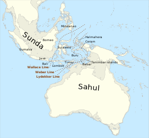
Geologically, the Sunda Shelf (/ˈsʌndə/[1]) is a south-eastern extension of the continental shelf of Mainland Southeast Asia. Major landmasses on the shelf include the Indonesian islands of Bali, Borneo, Java, Madura, and Sumatra, as well as their surrounding smaller islands.[2] It covers an area of approximately 1.85 million km2.[3] Sea depths over the shelf rarely exceed 50 metres and extensive areas are less than 20 metres resulting in strong bottom friction and strong tidal friction.[4] Steep undersea gradients separate the Sunda Shelf from the Philippines, Sulawesi, and the Lesser Sunda Islands (not including Bali).
- ^ https://www.collinsdictionary.com/dictionary/english/sunda-islands
- ^ Zvi Ben-Avraham, "Structural framework of the Sunda Shelf and vicinity" Structural Geology (January 1973) abstract; Monk, K.A.; Fretes, Y.; Reksodiharjo-Lilley, G. (1996). The Ecology of Nusa Tenggara and Maluku. Hong Kong: Periplus Editions Ltd. p. 10. ISBN 962-593-076-0.
- ^ va Bemmelen, R.W. (1949). The Geology of Indonesia. Vol. IA: General Geology of Indonesia and Adjacent Archipelagoes. Matinus Nithoff, The Hague, 723 pp.
- ^ Tomascik, T; Mah, J.A.; Nontji, A.; Moosa, M.K. (1996). The Ecology of the Indonesian Seas – Part One. Hong Kong: Periplus Editions Ltd. p. 74. ISBN 962-593-078-7.