Back Sungai Liat, Bangka BAN Sungailiat CEB Sungailiat German Sungai Liat, Bangka ID Sungailiat, Bangka MAP-BMS Sungailiat Malagasy Sungai Liat, Bangka MIN Sungai Liat, Bangka Malay Sungai Liat Polish Sungailiat Romanian
This article needs additional citations for verification. (April 2018) |
Sungailiat
Liet-kong | |
|---|---|
| Other transcription(s) | |
| • Jawi | سوڠايليات |
| • Mandarin | 双溪利亚 (Simplified) 雙溪利亞 (Traditional) Shuāng xī lì yǎ (Pinyin) |
| • Hakka | 烈港 (Hanzi) Lîet-kóng (Pha̍k-fa-sṳ) |
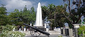
Zero kilometer mark · Kwan Ti Miau temple · Parai Tenggiri beach · Al Ittihad mosque · contemporary architecture | |
| Coordinates: 1°51′20.7″S 106°7′3.4″E / 1.855750°S 106.117611°E | |
| Country | |
| Province | Bangka Belitung Islands |
| Regency | Bangka Regency |
| Area | |
• Total | 146.38 km2 (56.52 sq mi) |
| Population (2018)[1] | |
• Total | 100,750 |
| • Density | 690/km2 (1,800/sq mi) |
| Time zone | UTC+7 (Western Indonesia Time) |
| Area code | +62717 |
| Sungailiat | |||||||||||||||||||
|---|---|---|---|---|---|---|---|---|---|---|---|---|---|---|---|---|---|---|---|
| Traditional Chinese | 雙溪利亞 | ||||||||||||||||||
| Simplified Chinese | 双溪利亚 | ||||||||||||||||||
| |||||||||||||||||||
| Liet-kong | |||||||||||||||||||
| Chinese | 烈港 | ||||||||||||||||||
| |||||||||||||||||||
Sungailiat, also known as Liet-kong in Hakka, is a town and district (kecamatan) of Bangka Regency, in the Bangka-Belitung province of Indonesia. It is also the regency seat.
It is the second-largest settlement on the island, right after the provincial capital of Pangkal Pinang. The town is located on the eastern coast of the island, about 30 kilometres north of Pangkal Pinang, to which it is connected by a paved road.
The district is further divided into 13, consisting of one 'desa/village and 12 kelurahan/urban village.
- ^ a b "Bangka Regency - Bureau of Statistics". Badan Pusat Statistik Kabupaten Bangka. Statistics Indonesia. Retrieved 4 August 2017.


