Back Suðraland ANG Sutherland Breton Sutherlandshire CEB Sutherland German Sutherland Esperanto Sutherland (Escocia) Spanish Sutherland Basque ساترلند Persian Sutherland (Écosse) French Cataibh Irish
Sutherland
Cataibh (Scottish Gaelic) | |
|---|---|
 | |
| Coordinates: 58°15′N 4°30′W / 58.250°N 4.500°W | |
| Sovereign state | |
| Country | |
| Council area | Highland |
| Area | |
• Total | 2,028 sq mi (5,252 km2) |
| Ranked 5th of 34 | |
| Population (2011) | |
• Total | 12,803 |
| • Density | 6.3/sq mi (2.4/km2) |
| Chapman code | SUT |
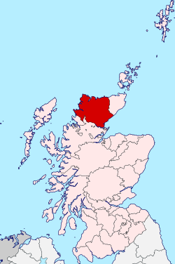
Sutherland (Scottish Gaelic: Cataibh) is a historic county, registration county and lieutenancy area in the Highlands of Scotland. The name dates from the Viking era when the area was ruled by the Jarl of Orkney; although Sutherland includes some of the northernmost land on the island of Great Britain, it was called Suðrland ("southern land") from the standpoint of Orkney and Caithness.
From the 13th century, Sutherland was a provincial lordship, being an earldom controlled by the Earl of Sutherland. The earldom just covered the south-eastern part of the later county. A shire called Sutherland was created in 1633, covering the earldom of Sutherland and the neighbouring provinces of Assynt to the west and Strathnaver to the north. Shires gradually eclipsed the old provinces in administrative importance, and also become known as counties.
The county is generally rural and sparsely populated. Sutherland was particularly affected by the Highland Clearances of the 18th and 19th centuries, and the population has been in decline since the mid-19th century. As at 2011 the population of the county was 12,803, being less than half of the peak of 25,793 which was recorded in 1851. Only one town held burgh status, being Dornoch, where the county's courts were held. Between 1890 and 1975 Sutherland had a county council, which had its main offices in the village of Golspie.
Sutherland has a coast to the east onto the Moray Firth and a coast to the north-west onto the Atlantic Ocean. Much of the county is mountainous, and the western and northern coasts include many high sea cliffs. There are four national scenic areas wholly or partly in the county: Assynt-Coigach, North West Sutherland, Kyle of Tongue and Dornoch Firth, with the first three of these lying along the western and northern coasts.
The county ceased to be used for local government purposes in 1975, when the area became part of the Highland region, which in turn became a single-tier council area in 1996. There was a local government district called Sutherland from 1975 to 1996, which was a lower-tier district within the Highland region, covering a similar but not identical area to the pre-1975 county. The pre-1975 county boundaries are still used for certain functions, being a registration county. The neighbouring counties prior to the 1975 reforms were Caithness to the north-east and Ross and Cromarty to the south.
The Sutherland lieutenancy area was redefined in 1975 to be the local government district. The registration county and the lieutenancy area therefore have slightly different definitions; the registration county does not include Kincardine, but the lieutenancy area does.
