Back Sydneybecken German Cuenca de Sídney Spanish Сіднейський вугільний басейн Ukrainian سڈنی بیسن Urdu
| Sydney Basin New South Wales | |||||||||||||||
|---|---|---|---|---|---|---|---|---|---|---|---|---|---|---|---|
 Map of the Sydney Basin | |||||||||||||||
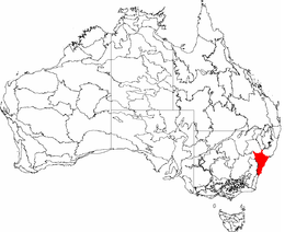
 The interim Australian bioregions, with the Sydney Basin in red | |||||||||||||||
| Coordinates | 33°56′53″S 150°45′36″E / 33.94806°S 150.76000°E | ||||||||||||||
| Population | 6,300,000[1] | ||||||||||||||
| • Density | 173.6/km2 (450/sq mi) | ||||||||||||||
| Area | 36,295.97 km2 (14,014.0 sq mi)[2] | ||||||||||||||
| |||||||||||||||
| |||||||||||||||
The Sydney Basin is an interim Australian bioregion and is both a structural entity and a depositional area, now preserved on the east coast of New South Wales, Australia and with some of its eastern side now subsided beneath the Tasman Sea. The basin is named for the city of Sydney, on which it is centred.
Around 5,000 metres (16,000 ft) thick, the Sydney Basin consists of Permian and Triassic sedimentary rocks, which stretches from Newcastle in the north to Batemans Bay in the south, and west to the Great Dividing Range. The basin is also home to the major centres of Newcastle, Gosford, and Wollongong, as well as the state capital of Sydney, and contains economically significant reserves of coal.
Sydney's famous harbour and the sculptured cliffs of the Blue Mountains are signature formations of relatively hard upper strata of sandstone. The basin contains the UNESCO World Heritage-listed Greater Blue Mountains Area.[3]
- ^ a b "Sydney Basin bioregion". Bioregional assessments. Australian Government. 28 September 2016. Retrieved 25 March 2018.
- ^ Cite error: The named reference
GAwas invoked but never defined (see the help page). - ^ Herbert, C., 1983. Geology of the Sydney Basin 1: 100 000 sheet 9130. New South Wales Department of Mineral Resources, Sydney.