Back منطقة تدمر Arabic منطقة تدمر ARZ Tadmur Azerbaijani Tadmur District CEB Tadmuri ringkond Estonian منطقه تدمر Persian District de Tadmor French Թադմորի գավառ Armenian Distrik Tadmur ID Distretto di Tadmor Italian
Tadmur District
منطقة تدمر | |
|---|---|
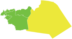
 Map of Tadmur District within Homs Governorate | |
| Coordinates (Tadmur): 34°36′N 38°18′E / 34.6°N 38.3°E | |
| Country | Syria |
| Governorate | Homs |
| Seat | Tadmur |
| Subdistricts | 2 nawāḥī |
| Area | |
• Total | 30,823.49 km2 (11,901.02 sq mi) |
| Population (2004)[1] | |
• Total | 76,942 |
| • Density | 2.5/km2 (6.5/sq mi) |
| Geocode | SY0405 |
Tadmur District (Arabic: منطقة تدمر, romanized: manṭiqat Tadmur) is a district of the Homs Governorate in central Syria. Administrative centre is the city of Tadmur, near ancient Palmyra/Tadmor. At the 2004 census, the district had a population of 76,942.[1]
- ^ a b "2004 Census Data". UN OCHA. Retrieved 15 October 2015.