Back Tannay, Ardennes BUG Tannay (Ardenes) Catalan Танне (АгӀденаш) CE Tannay, Ardennes CEB Tannay (Ardennes) Czech Tannay (Ardennes) German Tannay, Ardennes DIQ Tannay (Ardennes) Esperanto Tannay (Ardenas) Spanish Tannay (Ardenak) Basque
You can help expand this article with text translated from the corresponding article in French. (December 2008) Click [show] for important translation instructions.
|
Tannay | |
|---|---|
Part of Tannay-le-Mont-Dieu | |
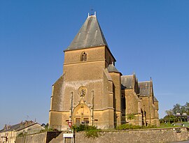
 The church in Tannay | |
| Coordinates: 49°31′38″N 4°50′01″E / 49.5272°N 4.8336°E | |
| Country | France |
| Region | Grand Est |
| Department | Ardennes |
| Arrondissement | Vouziers |
| Canton | Vouziers |
| Intercommunality | Argonne Ardennaise |
| Commune | Tannay-le-Mont-Dieu |
Area 1 | 14.04 km2 (5.42 sq mi) |
| Population (2022)[1] | 151 |
| • Density | 11/km2 (28/sq mi) |
| Time zone | UTC+01:00 (CET) |
| • Summer (DST) | UTC+02:00 (CEST) |
| Postal code | 08390 |
| Elevation | 160–276 m (525–906 ft) (avg. 202 m or 663 ft) |
| 1 French Land Register data, which excludes lakes, ponds, glaciers > 1 km2 (0.386 sq mi or 247 acres) and river estuaries. | |
Tannay (French pronunciation: [tanɛ] ⓘ) is a former commune in the Ardennes department and Grand Est region of north-eastern France. It was merged with Le Mont-Dieu to form Tannay-le-Mont-Dieu on 1 January 2025.[2]
- ^ "Populations de référence 2022" [Reference populations 2022] (PDF) (in French). INSEE. December 2024.
- ^ "Tannay-le-Mont-Dieu - fusion de Tannay et Le Mont-Dieu". Les services de l'État dans les Ardennes (in French). Retrieved 5 January 2025.


