Back تاردينهين Arabic تاردينهين ARZ Tardinghen AST Tardinghen Breton Tardinghen Catalan ТагӀденген CE Tardinghen CEB Tardinghen German Tardinghen DIQ Tardinghen Spanish
You can help expand this article with text translated from the corresponding article in French. (December 2021) Click [show] for important translation instructions.
|
Tardinghen
Terdingem (West Flemish) | |
|---|---|
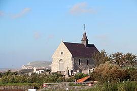
 The church of Tardinghen | |
| Coordinates: 50°52′01″N 1°37′52″E / 50.8669°N 1.6311°E | |
| Country | France |
| Region | Hauts-de-France |
| Department | Pas-de-Calais |
| Arrondissement | Boulogne-sur-Mer |
| Canton | Desvres |
| Intercommunality | CC Terre des Deux Caps |
| Government | |
| • Mayor (2020–2026) | Thibaut Segard[1] |
Area 1 | 8.72 km2 (3.37 sq mi) |
| Population (2022)[2] | 150 |
| • Density | 17/km2 (45/sq mi) |
| Time zone | UTC+01:00 (CET) |
| • Summer (DST) | UTC+02:00 (CEST) |
| INSEE/Postal code | 62806 /62179 |
| Elevation | 1–96 m (3.3–315.0 ft) (avg. 50 m or 160 ft) |
| 1 French Land Register data, which excludes lakes, ponds, glaciers > 1 km2 (0.386 sq mi or 247 acres) and river estuaries. | |
Tardinghen (French: [taʁdɛ̃ɡɑ̃]; West Flemish: Terdingem [tærˈdɛŋəm]; Picard: Tardinghin [taʀdɪˈŋɛ̃]) is a commune in the Pas-de-Calais department in the Hauts-de-France region of France[3] about 19 kilometres (12 mi) north of Boulogne, on Cape Gris-Nez.
- ^ "Répertoire national des élus: les maires". data.gouv.fr, Plateforme ouverte des données publiques françaises (in French). 2 December 2020.
- ^ "Populations de référence 2022" (in French). The National Institute of Statistics and Economic Studies. 19 December 2024.
- ^ "Commune de Tardinghen (62806)". INSEE. Retrieved 27 August 2024.


