Back Taroom CEB Taroom German Taroom Spanish تارووم Persian Taroom French Taroom Dutch Taroom Polish Taroom Swedish
| Taroom Queensland | |||||||||||||||
|---|---|---|---|---|---|---|---|---|---|---|---|---|---|---|---|
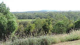
 View towards the north-west from Gilbert's Lookout, 2014 | |||||||||||||||
| Coordinates | 25°49′36″S 149°53′48″E / 25.8266°S 149.8966°E | ||||||||||||||
| Population | 885 (2021 census)[1] | ||||||||||||||
| • Density | 980/km2 (2,550/sq mi) | ||||||||||||||
| Postcode(s) | 4420 | ||||||||||||||
| Area | 0.9 km2 (0.3 sq mi) | ||||||||||||||
| Location | |||||||||||||||
| LGA(s) | |||||||||||||||
| State electorate(s) | Callide | ||||||||||||||
| Federal division(s) | Flynn | ||||||||||||||
| |||||||||||||||
Taroom /təˈruːm/ is a town in the Shire of Banana and locality split between the Shire of Banana and the Western Downs Region in Queensland, Australia.[2][3][4] In the 2021 census, Taroom had a population of 885 people.[1]
- ^ a b Australian Bureau of Statistics (28 June 2022). "Taroom (SAL)". 2021 Census QuickStats. Retrieved 19 June 2024.
- ^ "Taroom (town) (entry 33384)". Queensland Place Names. Queensland Government. Retrieved 15 May 2014.
- ^ "Taroom (locality) (entry 43728)". Queensland Place Names. Queensland Government. Retrieved 15 May 2014.
- ^ "Tarooom – locality in the Western Downs Region (entry 47750)". Queensland Place Names. Queensland Government. Retrieved 18 September 2017.
