Back Temora Municipality CEB Temora Shire German Comté de Temora French Contea di Temora Italian Temora Shire Council Dutch Temora Shire Swedish
| Temora Shire New South Wales | |||||||||||||||
|---|---|---|---|---|---|---|---|---|---|---|---|---|---|---|---|
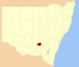
 Location in New South Wales | |||||||||||||||
| Population |
| ||||||||||||||
| • Density | 2.1806/km2 (5.648/sq mi) | ||||||||||||||
| Established | 1980 | ||||||||||||||
| Area | 2,802 km2 (1,081.9 sq mi) | ||||||||||||||
| Mayor | Cr. Rick Firman ()[3] | ||||||||||||||
| Council seat | Temora[4] | ||||||||||||||
| Region | Riverina | ||||||||||||||
| State electorate(s) | Cootamundra | ||||||||||||||
| Federal division(s) | Riverina | ||||||||||||||
 | |||||||||||||||
| Website | Temora Shire | ||||||||||||||
| |||||||||||||||
Temora Shire is a local government area in the Riverina region of New South Wales, Australia. It is on Burley Griffin Way. The Shire was created on 1 January 1981 via the amalgamation of Narraburra Shire and the Municipality of Temora.[5]
It includes the town of Temora and the small towns of Springdale, Sebastapol, Ariah Park, Gidginbung, Narraburra and Wallundry.
The mayor of Temora Shire is Cr. Rick Firman.[3]
- ^ Australian Bureau of Statistics (27 June 2017). "Temora (A)". 2016 Census QuickStats. Retrieved 8 December 2017.
- ^ "3218.0 – Regional Population Growth, Australia, 2017-18". Australian Bureau of Statistics. 27 March 2019. Retrieved 27 March 2019. Estimated resident population (ERP) at 30 June 2018.
- ^ a b Temora Shire Council, Current Councillors, retrieved 7 October 2016
- ^ "Temora Shire Council". Department of Local Government. Retrieved 1 December 2006.
- ^ "Past Presidents/Mayors". Temora Shire. Temora Shire Council. Retrieved 22 May 2016.