Back ثنية العابد Arabic ثنيه العابد ARZ ثنیه العابد AZB ثنیه العابد Persian Teniet El Abed French Théniet El Abed Italian Tizi n Lɛabed KAB Teniet El Abed Malay Teniet El Abed Portuguese Teniet El Abed Romanian
Teniet El Abed
ثية العابد ⵜⵉⵙⵉⵏⵜ ⵍⵄⴻⴱⴷ | |
|---|---|
 | |
 | |
| Coordinates: 35°14′49″N 6°11′26″E / 35.24694°N 6.19056°E | |
| Country | |
| Province | Batna |
| Population (2008) | |
• Total | 11,338 |
| Time zone | UTC+1 (West Africa Time) |
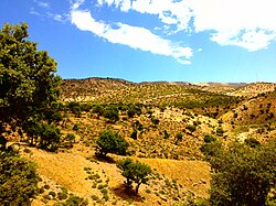
Teniet El Abed (Arabic: نية العابد) is a town in the Aurès Mountains of north-eastern Algeria. As of 2008 it had a population of 11,338 people. It is located along National Route 49, 59 kilometres (37 mi) south of Batna, 76 kilometres (47 mi) northeast of Biskra, and 122 kilometres (76 mi) west of Khenchela.
