Back Teotihuacán Afrikaans تيوتيهواكان Arabic تيوتيهواكان ARZ Teotihuacán AST Teotiuakan Azerbaijani Теотиуакан Bashkir Teotihuacan BAR Тэатыўакан Byelorussian Теотиуакан Bulgarian Teotihuacan BJN
This article needs additional citations for verification. (February 2021) |
19°41′33″N 98°50′38″W / 19.69250°N 98.84389°W
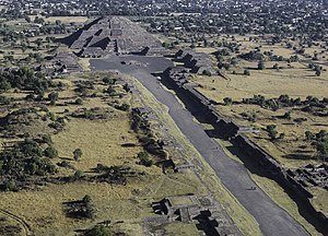
 View of the Avenue of the Dead and the Pyramid of the Moon. | |
| Location | Teotihuacán, State of Mexico, Mexico |
|---|---|
| Coordinates | 19°41′33″N 98°50′38″W / 19.69250°N 98.84389°W |
| History | |
| Periods | Late Preclassic to late Classic |
| Site notes | |
| Architecture | |
| Architectural styles | Talud-tablero |
| Official name | Pre-Hispanic City of Teotihuacan |
| Criteria | Cultural: i, ii, iii, iv, vi |
| Reference | 414 |
| Inscription | 1987 (11th Session) |
| Area | 3,381.71 ha |
Teotihuacan (/teɪˌoʊtiːwəˈkɑːn/;[1] Spanish: Teotihuacán, Spanish pronunciation: [teotiwa'kan] ⓘ; ⓘ) is an ancient Mesoamerican city located in a sub-valley[2] of the Valley of Mexico, which is located in the State of Mexico, 40 kilometers (25 mi) northeast of modern-day Mexico City.[3]
Teotihuacan is known today as the site of many of the most architecturally significant Mesoamerican pyramids built in the pre-Columbian Americas, namely the Pyramid of the Sun and the Pyramid of the Moon. Although close to Mexico City, Teotihuacan was not a Mexica (i.e. Aztec) city, and it predates the Aztec Empire by many centuries. At its zenith, perhaps in the first half of the first millennium (1 CE to 500 CE), Teotihuacan was the largest city in the Americas, with a population of at least 25,000,[4] but has been estimated at 125,000 or more,[5][6] making it at least the sixth-largest city in the world during its epoch.[7]
The city covered eight square miles (21 km2) and 80 to 90 percent of the total population of the valley resided in Teotihuacan. Apart from the pyramids, Teotihuacan is also anthropologically significant for its complex, multi-family residential compounds, the Avenue of the Dead, and its vibrant, well-preserved murals. Additionally, Teotihuacan exported fine obsidian tools found throughout Mesoamerica. The city is thought to have been established around 100 BCE, with major monuments continuously under construction until about 250 CE.[5] The city may have lasted until sometime between the 7th and 8th centuries CE, but its major monuments were sacked and systematically burned around 550 CE. Its collapse might be related to the extreme weather events of 535–536.
Teotihuacan began as a religious center in the Mexican Plateau around the first century CE. It became the largest and most populated center in the pre-Columbian Americas. Teotihuacan was home to multi-floor apartment compounds built to accommodate the large population.[5] The term Teotihuacan (or Teotihuacano) is also used to refer to the whole civilization and cultural complex associated with the site.
Although it is a subject of debate whether Teotihuacan was the center of a state empire, its influence throughout Mesoamerica is well documented. Evidence of Teotihuacano presence is found at numerous sites in Veracruz and the Maya region. The later Aztecs saw these magnificent ruins and claimed a common ancestry with the Teotihuacanos, modifying and adopting aspects of their culture. The ethnicity of the inhabitants of Teotihuacan is the subject of debate. Possible candidates are the Nahua, Otomi, or Totonac ethnic groups. Other scholars have suggested that Teotihuacan was multi-ethnic, due to the discovery of cultural aspects connected to the Maya as well as Oto-Pamean people. It is clear that many different cultural groups lived in Teotihuacan during the height of its power, with migrants coming from all over, but especially from Oaxaca and the Gulf Coast.[8][9]
After the collapse of Teotihuacan, central Mexico was dominated by more regional powers, notably Xochicalco and Tula.
The city and the archeological site are located in what is now the San Juan Teotihuacán municipality in the State of México, approximately 40 kilometers (25 mi) northeast of Mexico City. The site covers a total surface area of 83 square kilometers (32 sq mi) and was designated a UNESCO World Heritage Site in 1987.[10] It is the most-visited archeological site in Mexico, receiving 4,185,017 visitors in 2017.[11]
- ^ "Teotihuacán". Oxford Dictionaries. Oxford University Press. Archived from the original on 16 July 2013. Retrieved 30 May 2013.
- ^ "Teotihuacan Valley" [Teotihuacan Valley]. Mexican Routes. 2024-12-30. Retrieved 30 December 2024.
- ^ "Pre-Hispanic City of Teotihuacan | Whizzed Net". www.whizzed.net. 28 October 2023. Retrieved 2023-11-04.
- ^ Centre, UNESCO World Heritage. "Pre-Hispanic City of Teotihuacan". UNESCO World Heritage Centre. Retrieved 2024-09-14.
- ^ a b c "Teotihuacan". Heilbrunn Timeline of Art History. Department of Arts of Africa, Oceania, and the Americas, The Metropolitan Museum of Art.
- ^ Millon, p. 18.
- ^ Millon, p. 17, who says it was the sixth-largest city in the world in 600 AD.
- ^ SPENCE, MICHAEL W.; WHITE, CHRISTINE D.; RATTRAY, EVELYN C.; LONGSTAFFE, FRED J. (2006-12-31), "Past Lives in Different Places", Settlement, Subsistence, and Social Complexity, Cotsen Institute of Archaeology Press, pp. 155–197, doi:10.2307/j.ctvdjrqh6.9, retrieved 2022-02-22
- ^ Price, T.Douglas; Manzanilla, Linda; Middleton, William D. (October 2000). "Immigration and the Ancient City of Teotihuacan in Mexico: a Study Using Strontium Isotope Ratios in Human Bone and Teeth". Journal of Archaeological Science. 27 (10): 903–913. Bibcode:2000JArSc..27..903P. doi:10.1006/jasc.1999.0504. ISSN 0305-4403.
- ^ Centre, UNESCO World Heritage. "Pre-Hispanic City of Teotihuacan". whc.unesco.org. Retrieved 2018-02-08.
- ^ "Estadística de Visitantes" (in Spanish). INAH. Retrieved 25 March 2018.


