Back Hill Country Czech منطقه تپهزاری تگزاس Persian Texas Hill Country French Texas Hill Country Italian テキサス・ヒル・カントリー Japanese
Texas Hill Country | |
|---|---|
 Hill Country State Natural Area in Bandera County | |
 Map of Texas Hill Country | |
| Coordinates: 30°10′27″N 99°03′55″W / 30.17417°N 99.06528°W | |
| Location | Central Texas, United States |
| Elevation | 980–2,460 ft (300–750 m) |
The Texas Hill Country is a geographic region of Central and South Texas, forming the southeast part of the Edwards Plateau. Given its location, climate, terrain, and vegetation, the Hill Country can be considered the border between the American South and Southwest.[1] The region represents the very remote rural countryside of Central Texas, but also is home to growing suburban neighborhoods and affluent retirement communities.[2]
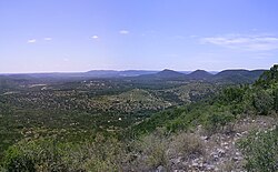
The region is notable for its karst topography and tall rugged hills of limestone or granite.[1] Many of the hills rise to a height of 400–500 ft (120–150 m) above the surrounding plains and valleys, with Packsaddle Mountain rising to a height of 800 ft (240 m) above the Llano River in Kingsland.[3] The Hill Country also includes the Llano Uplift and the second-largest granite dome in the United States, Enchanted Rock. The terrain throughout the region is characterized by a thin layer of topsoil and many exposed rocks and boulders, making the region very dry and prone to flash flooding. Native vegetation in the region includes various yucca, prickly pear cactus, desert spoon, and wildflowers in the Llano Uplift. The predominant trees in the region are Ashe juniper and Texas live oak.[4]
Bound on the east by the Balcones Escarpment, the Hill Country reaches into the far northern portions of San Antonio and western portions of Travis County including the cities of Austin and Lago Vista. As a result of springs discharging water stored in the Edwards Aquifer, several cities such as Austin, San Marcos, and New Braunfels were settled at the base of the Balcones Escarpment. As of 2016[update], the region's economy was one of the fastest growing in the United States.[5][6]
- ^ a b Jordan, Terry G. "Hill Country". Handbook of Texas Online. Retrieved November 7, 2009.
- ^ Dizik, Alina (June 8, 2018). "In Texas Hill Country, a Land Rush for the Rich". Retrieved October 22, 2020.
- ^ Google Earth Terrain Data
- ^ Lehman, Roy L.; Ruth O'Brien; Tammy White (2005). Plants of the Texas Coastal Bend. Texas A&M University Press. ISBN 978-1-58544-408-3.
- ^ "America's Next Great Metropolis Is Taking Shape In Texas". Forbes. October 13, 2016. Retrieved October 17, 2016.
- ^ "The City of the Eternal Boom". TexasMonthly.com. February 24, 2016. Retrieved January 25, 2017.