Back আম্ফোয়ে থা চাং (সুরাত থানি) BPY Amphoe Tha Chang (distrito sa Thayland, Changwat Surat Thani) CEB Amphoe Tha Chang (Surat Thani) German Distretto di Tha Chang (Surat Thani) Italian ターチャーン郡 (スラートターニー県) Japanese 타창군 (수랏타니주) Korean Tha Chang Portuguese Districtul Tha Chang, Surat Thani Romanian อำเภอท่าฉาง Thai Tha Chang, Surat Thani Vietnamese
Tha Chang
ท่าฉาง | |
|---|---|
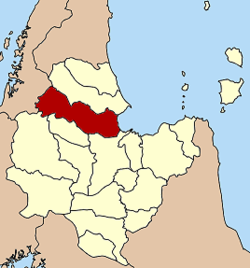
 District location in Surat Thani province | |
| Coordinates: 9°16′51″N 99°12′3″E / 9.28083°N 99.20083°E | |
| Country | Thailand |
| Province | Surat Thani |
| Seat | Khao Than |
| Area | |
• Total | 1,167.7 km2 (450.9 sq mi) |
| Population (2005) | |
• Total | 31,013 |
| • Density | 26.56/km2 (68.8/sq mi) |
| Time zone | UTC+7 (ICT) |
| Postal code | 84150 |
| Geocode | 8411 |
Tha Chang (Thai: ท่าฉาง, pronounced [tʰâː t͡ɕʰǎːŋ]) is a district (amphoe) in the west of Surat Thani province of southern Thailand.
Neighboring districts are Chaiya to the north, and to the west the district Kapoe of Ranong province. Bandon Bay to the east, Phunphin district, Vibhavadi and Ban Ta Khun to the south,