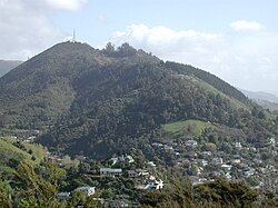
The Brook | |
|---|---|
Suburb | |
 Grampians Reserve in The Brook | |
 | |
| Coordinates: 41°17′46″S 173°17′53″E / 41.296°S 173.298°E | |
| Country | New Zealand |
| Region | Nelson |
| Ward |
|
| Electorates | |
| Government | |
| • Territorial Authority | Nelson City Council |
| • Nelson City Mayor | Nick Smith |
| • Nelson MP | Rachel Boyack |
| • Te Tai Tonga MP | Tākuta Ferris |
| Area | |
• Total | 6.91 km2 (2.67 sq mi) |
| • Land | 6.91 km2 (2.67 sq mi) |
| • Water | 0 km2 (0 sq mi) |
| Population (June 2024)[2] | |
• Total | 2,030 |
| • Density | 290/km2 (760/sq mi) |
| Time zone | UTC+12 (NZST) |
| • Summer (DST) | UTC+13 (NZDT) |
| Postcode | 7010 |
| Area code | 03 |
The Brook is one of the suburbs of Nelson, New Zealand. It lies to the south of Nelson and is the location of the Brook Waimārama Sanctuary, a conservation project at the head of the Brook Valley.[3]
- ^ Cite error: The named reference
Areawas invoked but never defined (see the help page). - ^ "Aotearoa Data Explorer". Statistics New Zealand. Retrieved 26 October 2024.
- ^ Arnold, Naomi (29 April 2013). "Two Sides of the Fence". Stuff.co.nz. Retrieved 2 May 2014.
