Back حديقة ثيودور روزفلت الوطنية Arabic Taman Nasional Theodore Roosevelt BAN Нацыянальны парк Тэадор Рузвельт Byelorussian Теодор Рузвелт (национален парк) Bulgarian Parc Nacional Theodore Roosevelt Catalan Theodore Roosevelt National Park CEB Národní park Theodore Roosevelt Czech Theodore Roosevelt National Park Danish Theodore-Roosevelt-Nationalpark German Parque nacional Theodore Roosevelt Spanish
| Theodore Roosevelt National Park | |
|---|---|
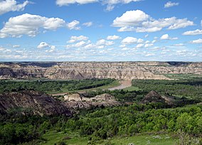
 View of the badlands and the Little Missouri River | |
| Location | Billings and McKenzie counties, North Dakota, United States |
| Nearest city | Medora |
| Coordinates | 46°58′N 103°27′W / 46.967°N 103.450°W |
| Area | 70,446 acres (285.08 km2)[1] |
| Established | November 10, 1978 |
| Visitors | 668,679 (in 2022)[2] |
| Governing body | National Park Service |
| Website | Theodore Roosevelt National Park |
Theodore Roosevelt National Park is a national park of the United States in the badlands of western North Dakota comprising three geographically separated areas. This park pays homage to the time that Theodore Roosevelt spent in the surrounding area and in the Dakota Territories before they were states. Roosevelt lived in the area after his mother and wife died hours apart on February 14, 1884. Theodore Roosevelt National Park is the only American national park named directly after a single person.
The park covers 70,446 acres (110.072 sq mi; 28,508 ha; 285.08 km2) of land in three sections: the North Unit, the South Unit, and the Elkhorn Ranch Unit. The Little Missouri River flows through all three units of the park. The Maah Daah Hey Trail connects all three units. The park's larger South Unit lies alongside Interstate 94 near Medora, North Dakota. The smaller North Unit is situated about 80 mi (130 km) north of the South Unit, and Roosevelt's Elkhorn Ranch is located between the North and South units.
Both main units of the park have scenic drives, approximately 100 miles (160 km) of foot and horse trails, wildlife viewing, and back country hiking and camping. The park received 850,000 recreational visitors in 2021.[2]
- ^ "Listing of acreage – December 31, 2011" (XLSX). Land Resource Division, National Park Service. Retrieved May 13, 2012. (National Park Service Acreage Reports)
- ^ a b "NPS Annual Recreation Visits Report". National Park Service. Retrieved July 23, 2023.

