Back Tessin (Fluss) ALS نهر تسين Arabic نهر تسين ARZ تیچینو چایی AZB Тычына (рака) Byelorussian Тичино Bulgarian Ticino (stêr) Breton Riu Ticino Catalan Fiume Ticino CEB Ticino Czech
| Ticino | |
|---|---|
 The Ticino and the Ponte Coperto of Pavia (originally medieval in date, rebuilt in 1950 after the destruction due to war bombing) | |
 | |
| Native name | Tesin (Lombard) |
| Location | |
| Country | Switzerland, Italy |
| Physical characteristics | |
| Source | |
| • location | Val Bedretto, Ticino, Switzerland |
| • elevation | about 2,478 m (8,100 ft) |
| Mouth | Po |
• location | south-east of Pavia, Italy |
• coordinates | 45°08′38″N 9°14′12″E / 45.14389°N 9.23667°E |
| Length | 248 km (154 mi) |
| Basin size | 7,228 km2 (2,791 sq mi) |
| Discharge | |
| • average | 348 m3/s or 12,300 cu ft/s |
| • minimum | 54 m3/s or 1,900 cu ft/s |
| • maximum | 5,000 m3/s or 180,000 cu ft/s |
| Discharge | |
| • location | Bellinzona |
| • average | 70 m3/s or 2,500 cu ft/s (MQ) |
| • minimum | 14.5 m3/s or 510 cu ft/s (1Q) |
| • maximum | 906 m3/s or 32,000 cu ft/s (mHQ), 1,500 m3/s or 53,000 cu ft/s (HHQ) |
| Basin features | |
| Progression | Po→ Adriatic Sea |
 | |
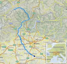
The river Ticino (/tɪˈtʃiːnoʊ/ titch-EE-noh, Italian: [tiˈtʃiːno]; Lombard: Tesin; French and German: Tessin; Latin: Ticīnus) is the most important perennial left-bank tributary of the Po. It has given its name to the Swiss canton through which its upper portion flows.
It is one of the four major rivers taking their source in the Gotthard region, along with the Rhône, Reuss and Rhine.[1] The river rises in the Val Bedretto in Switzerland at the frontier between the cantons of Valais and Ticino right below the Nufenen Pass, is fed by the glaciers of the Alps and later flows through Lake Maggiore, which traverses the border to Italy. The Ticino joins the Po a few kilometres downstream (along the Ticino) from Pavia.[2] It is about 248 kilometres (154 mi) long. The stretch of river between Lake Maggiore and the confluence in the Po is included in the Parco naturale lombardo della Valle del Ticino, a Nature reserve included by UNESCO in the World Network of Biosphere Reserves.[3]
- ^ John Murray, A Handbook for Travellers in Switzerland, and the Alps of Savoy and Piedmont, Outlook, 2002 ISBN 3752586109 pp 119
- ^ Rodolfo Soncini-Sessa; Enrico Weber; Francesca Cellina; Francesca Pianosi (2007). Integrated and Participatory Water Resources Management - Practice. Elsevier Science. p. 40. ISBN 9780080551425.
- ^ Unesco. "Ticino, Val Grande Verbano". unesco.org. Unesco. Retrieved 7 July 2024.