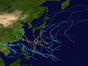
| Timeline of the 2005 Pacific typhoon season | |||||
|---|---|---|---|---|---|
 Season summary map | |||||
| Season boundaries | |||||
| First system formed | January 13, 2005 | ||||
| Last system dissipated | December 21, 2005 | ||||
| Strongest system | |||||
| Name | Haitang | ||||
| Maximum winds | 220 km/h (140 mph) (10-minute sustained) | ||||
| Lowest pressure | 920 hPa (mbar) | ||||
| Longest lasting system | |||||
| Name | ??? | ||||
| Duration | ?? days | ||||
| |||||
This timeline documents all of the events of the 2005 Pacific typhoon season, the period that tropical cyclones formed in the Western Pacific Ocean during the year. The scope of this article is limited to the Pacific Ocean, north of the equator between 100°E and the International Date Line. Tropical depressions that form in the basin were given a number with a "W" suffix by the United States' Joint Typhoon Warning Center (JTWC). If a depression intensified into a tropical storm, it would be assigned a name by the Japan Meteorological Agency (JMA). In addition, the Philippine Atmospheric, Geophysical and Astronomical Services Administration (PAGASA) assigned names to tropical cyclones which were in their area of responsibility.
During the season, a total of 33 systems were designated as tropical depressions by either the Japan Meteorological Agency (JMA), the Philippine Atmospheric, Geophysical and Astronomical Services Administration (PAGASA), the Joint Typhoon Warning Center (JTWC), or other national meteorological and hydrological services such as the China Meteorological Administration and the Hong Kong Observatory. Because the JMA runs the Regional Specialized Meteorological Centre for the Western Pacific, they assigned names to these systems once they intensified into a tropical storm. PAGASA also assigned their own local names to systems which were active within their area of responsibility; however, these names are not in common use outside of PAGASA's area of responsibility.
