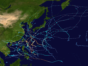
| Timeline of the 2012 Pacific typhoon season | |||||
|---|---|---|---|---|---|
 Season summary map | |||||
| Season boundaries | |||||
| First system formed | January 13, 2012 | ||||
| Last system dissipated | December 29, 2012 | ||||
| Strongest system | |||||
| Name | Sanba | ||||
| Maximum winds | 205 km/h (125 mph) (10-minute sustained) | ||||
| Lowest pressure | 900 hPa (mbar) | ||||
| Longest lasting system | |||||
| Name | Prapiroon | ||||
| Duration | 14 days | ||||
| |||||
This timeline documents all of the events of the 2012 Pacific typhoon season. The scope of this article is limited to the Pacific Ocean, north of the equator between 100°E and the International Date Line. During the season, 34 systems were designated as tropical depressions by either the Japan Meteorological Agency (JMA), the Philippine Atmospheric, Geophysical and Astronomical Services Administration (PAGASA), the Joint Typhoon Warning Center (JTWC), or other National Meteorological and Hydrological Services such as the China Meteorological Administration and the Hong Kong Observatory. Since the JMA runs the Regional Specialized Meteorological Centre (RSMC) for the Western Pacific, they assigned names to tropical depressions which developed into tropical storms in the basin. PAGASA also assigned local names to systems which are active in their area of responsibility; however, these names are not in common use outside of the Philippines.
For the PAGASA, 17 systems formed or entered in area of responsibility during 2012, which 7 of them directly made landfall over the Philippines. The season started by the formation of a depression on January 13, but the JMA reported that the season had started on January 1 by a tropical depression which formed on December 31, 2011. 7 typhoons underwent rapid deepening. From late August to September, three very powerful typhoons, Bolaven, Sanba and Jelawat, directly hit Okinawa Island successively. In October, the remnants of Severe Tropical Storm Gaemi arrived at the Bay of Bengal and re-intensified into a deep depression before making landfall over Bangladesh.
