| Timeline of the 2014 Pacific typhoon season | |
|---|---|
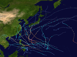
 Season summary map | |
| Season boundaries | |
| First system formed | January 10, 2014 |
| Last system dissipated | January 1, 2015 |
| Strongest system | |
| Name | Vongfong |
| Maximum winds | 215 km/h (130 mph) (10-minute sustained) |
| Lowest pressure | 900 hPa (mbar) |
| Longest lasting system | |
| Name | Halong |
| Duration | 15 days |
This timeline documents all of the events of the 2014 Pacific typhoon season. Most of the tropical cyclones forming between May and November. The scope of this article is limited to the Pacific Ocean, north of the equator between 100°E and the International Date Line. Tropical storms that form in the entire Western Pacific basin are assigned a name by the Japan Meteorological Agency. Tropical depressions that form in this basin are given a number with a "W" suffix by the United States' Joint Typhoon Warning Center. In addition, the Philippine Atmospheric, Geophysical and Astronomical Services Administration (PAGASA) assigns names to tropical cyclones (including tropical depressions) that enter or form in the Philippine area of responsibility. These names, however, are not in common use outside of the Philippines.
During the season, 30 systems were designated as Tropical Depressions by either, the Japan Meteorological Agency (JMA), the Philippine Atmospheric, Geophysical and Astronomical Services Administration (PAGASA), the Joint Typhoon Warning Center (JTWC), or other National Meteorological and Hydrological Services such as the China Meteorological Administration and the Hong Kong Observatory. As they run the Regional Specialized Meteorological Centre for the Western Pacific, the JMA assigns names to Tropical Depressions should they intensify into a tropical storm. PAGASA also assign local names to tropical depressions which form within their area of responsibility; however, these names are not in common use outside of PAGASA's area of responsibility. In this season, 19 systems entered or formed in the Philippine area of responsibility, which eight of them directly made landfall over the Philippines.
The first half of the season was relatively active with seven named storms. During the season, six typhoons underwent rapid deepening. The deadliest and damaging storm so far is Rammasun, killing nearly 200 people with damages of about $7 billion. During August, Hurricane Genevieve entered the basin as a super typhoon. During mid-August, as Genevieve began to weaken, tropical activity in the Northwest Pacific began to decrease, making it the first time no tropical storms develop during the peak of the season since records began. This also occurred for the second time during mid-October, after the dissipation of Vongfong. In early October, Vongfong reached its peak intensity as a strong Category 5 typhoon, the strongest since Typhoon Haiyan in November 2013.
