Back Tlaxcala Afrikaans Tlaxcala AN ولاية تلاكسكالا Arabic Tlaxcala Istadu Aymara Тласкала Byelorussian Тляскаля (штат) BE-X-OLD Тласкала Bulgarian Tlaxcala Breton Estat de Tlaxcala Catalan Тласкала (штат) CE
You can help expand this article with text translated from the corresponding article in Spanish. (January 2023) Click [show] for important translation instructions.
|
Tlaxcala
Tlaxcallan (Nahuatl) | |
|---|---|
| Free and Sovereign State of Tlaxcala Estado Libre y Soberano de Tlaxcala (Spanish) Tlahtohcayotl Tlaxcallan (Nahuatl) | |
 View of Malinche (volcano) | |
| Motto: Cuna de la Nación(Cradle of the Nation) | |
| Anthem: Himno a Tlaxcala | |
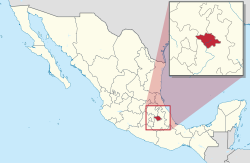
 State of Tlaxcala within Mexico | |
| Coordinates: 19°26′N 98°10′W / 19.433°N 98.167°W | |
| Country | Mexico |
| Capital and largest city | Tlaxcala de Xicohténcatl |
| Municipalities | 60 |
| Admission | December 9, 1856[1] |
| Order | 22nd |
| Government | |
| • Governor | Lorena Cuéllar |
| • Senators[2] | Joel Molina Ramírez Ana Lilia Rivera Rivera Minerva Hernández Ramos |
| • Deputies[3] | |
| Area | |
• Total | 4,016 km2 (1,551 sq mi) |
| Ranked 31st | |
| Highest elevation | 4,420 m (14,500 ft) |
| Population (2020)[5] | |
• Total | 1,342,977 |
| • Rank | 28th |
| • Density | 330/km2 (870/sq mi) |
| • Rank | 3rd |
| Demonym | Tlaxcalan |
| GDP | |
| • Total | MXN 158 billion (US$7.8 billion) (2022) |
| • Per capita | (US$5,594) (2022) |
| Time zone | UTC−6 (Central) |
| Postal code | 90 |
| Area code | |
| ISO 3166 code | MX-TLA |
| HDI | |
| Website | Official Web Site |
Tlaxcala,[a] officially the Free and Sovereign State of Tlaxcala,[b] is one of the 32 federal entities that comprise the Federal Entities of Mexico. It is divided into 60 municipalities and the capital city and the largest city is Tlaxcala de Xicohténcatl.
It is located in east-central Mexico, in the altiplano region, with the eastern portion dominated by the Sierra Madre Oriental.[7] It is bordered by the states of Puebla to the north, east and south, México to the west and Hidalgo to the northwest. It is the smallest state of the republic, accounting for only 0.2% of the country's territory.[7]
The state is named after its capital, Tlaxcala, which was also the name of the Pre-Columbian city and culture. The Tlaxcaltec people allied themselves with the Spanish to defeat the Aztecs, with concessions from the Spanish that allowed the territory to remain mostly intact throughout 300 years of colonial period.[8] After Mexican Independence, Tlaxcala was declared a federal territory, until 1857 when it was admitted as a state of the federation.
Most of the state's economy is based on agriculture, light industry and tourism. The tourist industry is rooted in Tlaxcala's long history with major attractions being archeological sites such as Cacaxtla and colonial constructions in and around Tlaxcala City.[9]
- ^ "Portal Gobierno del Estado de Tlaxcala" (in Spanish). Archived from the original on 2009-12-27.
- ^ "Senadores por Tlaxcala LXI Legislatura". Senado de la Republica. Archived from the original on December 16, 2003. Retrieved October 20, 2010.
- ^ "Listado de Diputados por Grupo Parlamentario del Estado de Tlaxcala". Camara de Diputados. Archived from the original on August 21, 2012. Retrieved October 20, 2010.
- ^ "Relieve". Cuentame INEGI. Archived from the original on September 30, 2011. Retrieved October 20, 2010.
- ^ "México en cifras". January 2016.
- ^ Citibanamex (June 13, 2023). "Indicadores Regionales de Actividad Económica 2023" (PDF) (in Spanish). Retrieved August 13, 2023.
- ^ a b "Geografia" (in Spanish). Tlaxcala: State of Tlaxcala. Archived from the original on August 14, 2009. Retrieved August 15, 2009.
- ^ Schmal, John P. (2004). "The History of the Tlaxcalans". Houston Institute for Culture. Houston.
- ^ Solis, Felipe (2000). "Herencia arqueológica en Tlaxcala". Mexico Desconocido:Tlaxcala (in Spanish). 106. Mexico City: Editorial Mexico Desconocido: 7–13. ISSN 0188-5146.
Cite error: There are <ref group=lower-alpha> tags or {{efn}} templates on this page, but the references will not show without a {{reflist|group=lower-alpha}} template or {{notelist}} template (see the help page).

