Back Tourouvre au Perche AST Tourouvre au Perche German Τουρούβρ ω Περς Greek Tourouvre au Perche Esperanto Tourouvre au Perche Spanish Tourouvre au Perche French Tourouvre au Perche Kurdish Tourouvre au Perche Dutch Tourouvre au Perche Polish Tourouvre au Perche Portuguese
Tourouvre au Perche | |
|---|---|
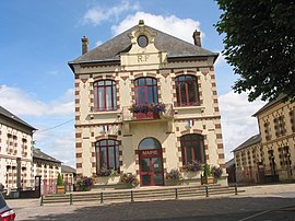
 The town hall in Tourouvre au Perche | |
| Coordinates: 48°35′24″N 0°39′07″E / 48.590°N 0.652°E | |
| Country | France |
| Region | Normandy |
| Department | Orne |
| Arrondissement | Mortagne-au-Perche |
| Canton | Tourouvre au Perche |
| Intercommunality | CC Hauts Perche |
| Government | |
| • Mayor (2020–2026) | Franck Poirier[1] |
Area 1 | 93.76 km2 (36.20 sq mi) |
| Population (2022)[2] | 2,989 |
| • Density | 32/km2 (83/sq mi) |
| Time zone | UTC+01:00 (CET) |
| • Summer (DST) | UTC+02:00 (CEST) |
| INSEE/Postal code | 61491 /61190 |
| 1 French Land Register data, which excludes lakes, ponds, glaciers > 1 km2 (0.386 sq mi or 247 acres) and river estuaries. | |
Tourouvre au Perche (French pronunciation: [tuʁuvʁ o pɛʁʃ]) is a commune in the department of Orne, northwestern France. The municipality was established on 1 January 2016 by merger of the former communes of Autheuil, Bivilliers, Bresolettes, Bubertré, Champs, Lignerolles, La Poterie-au-Perche, Prépotin, Randonnai and Tourouvre (the seat).[3]
The commune is listed as a Village étape.[4][5]
- ^ "Répertoire national des élus: les maires" (in French). data.gouv.fr, Plateforme ouverte des données publiques françaises. 13 September 2022.
- ^ "Populations de référence 2022" (in French). The National Institute of Statistics and Economic Studies. 19 December 2024.
- ^ Arrêté préfectoral 21 December 2015 (in French)
- ^ "A Tourouvre, le label village étape c'est bon pour le tourisme". actu.fr. 24 September 2021.
- ^ "Tourouvre – Les Villages Étapes".


