Back Trans-Pecos Czech Trans-Pecos French Transpecos Frisian Trans-Pecos Italian Transpekosas Lithuanian Trans-Pecos NB 外佩科斯地區 Chinese
Trans-Pecos | |
|---|---|
 Ocotillo in the Chihuahuan Desert of the Trans-Pecos | |
 | |
| Country | |
| State | |
| Largest city | El Paso |
| Area | |
| • Land | 81,530 km2 (31,479 sq mi) |
| Population (2020) | 919,421 |
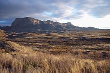
The Trans-Pecos, as originally defined in 1887 by the Texas geologist Robert T. Hill, is the distinct portion of Texas that lies west of the Pecos River.[1] The term is considered synonymous with Far West Texas, a subdivision of West Texas.[2] The Trans-Pecos is part of the Chihuahuan Desert, the largest desert in North America. It is the most mountainous and arid portion of the state, and most of its vast area (outside the city of El Paso) is sparsely populated. Among the nine counties in the region are the five largest counties by area in Texas and eight of the eleven largest in the state. The area is known for the natural environment of the Big Bend and the gorge of the Rio Grande, part of which has been designated a National Wild and Scenic Rivers System. With the notable exceptions of Big Bend Ranch State Park, Big Bend National Park and the Guadalupe Mountains National Park, the vast majority of the Trans-Pecos region consists of privately owned ranchland. However, most of the region's population reside in the El Paso metropolitan area. Besides El Paso and its metropolitan area, the major cities are Pecos (12,916), Fort Stockton (8,466), and Alpine (6,035). All other settlements have under 5,000 people.


- ^ Hill, R. T. (1887). "The topography and geology of the Cross Timbers and surrounding regions in Northern Texas". The American Journal of Science. 3rd Series. 33: 291–303. doi:10.2475/ajs.s3-33.196.291. ISSN 1945-452X.
- ^ Greene, A. C. (1998). Sketches from the Five States of Texas. College Station: Texas A&M University Press. ISBN 0-89096-842-X.