.svg) | |
|---|---|
.svg) | |
| Route information | |
| Length | 1,539 km (956 mi) |
| Existed | July 24, 1925–present |
| Location | |
| Country | Venezuela |
| Highway system | |
The Trans-Andean Highway (official designation Troncal 7, official name Carretera Trasandina), was inaugurated on July 24, 1925. It is 1,539 km long. It runs through the Venezuelan states of Mérida, Trujillo and Táchira, from the proximities of Agua Viva up until San Cristóbal. Its highest point is located on Collado del Cóndor, at 4,118 meters (13,510 ft), making it the highest highway in Venezuela.[1]
-
 Collado del Cóndor, highest point in Trans-andean highway.
 -
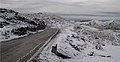
 View of a snowfall on Trans-Andean Highway.
 -
 Most of its route has beautiful scenic views.


- ^ "Un Paseo por el Páramo Merideño". MeridaPreciosa.com (in Spanish).
la carretera trasandina, inaugurada por Juan Vicente Gómez en el año 1925, la cual remonta la cordillera hasta una altura máxima de 4.118 m.s.n.m, que culmina en el Collado del Nido del Cóndor, mejor conocido como Pico El Águila