Back Transantarktiese Berge Afrikaans سلسلة الجبال العابرة للقارة القطبية الجنوبية Arabic Montes Tresantárticos AST Transantarktika dağları Azerbaijani Трансантарктик тауҙар Bashkir Трансантарктычныя горы Byelorussian Трансантарктычныя горы BE-X-OLD Трансантарктически планини Bulgarian ট্রান্স-অ্যান্টার্কটিক পর্বতমালা Bengali/Bangla Transantarktičke planine BS
| Transantarctic Mountains | |
|---|---|
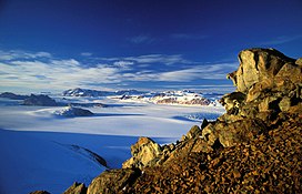
 The Transantarctic Mountains in northern Victoria Land near Cape Roberts | |
| Highest point | |
| Peak | Mount Kirkpatrick |
| Elevation | 4,528 m (14,856 ft) |
| Coordinates | 84°20′S 166°25′E / 84.333°S 166.417°E |
| Dimensions | |
| Length | 3,500 km (2,200 mi) |
| Geography | |
| Continent | Antarctica |
| Range coordinates | 85°S 175°W / 85°S 175°W |
| Geology | |
| Rock age | Cenozoic |
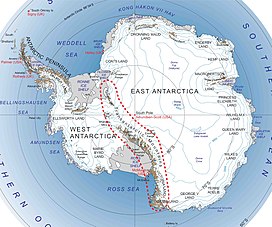
The Transantarctic Mountains (abbreviated TAM) comprise a mountain range of uplifted rock (primarily sedimentary) in Antarctica which extends, with some interruptions, across the continent from Cape Adare in northern Victoria Land to Coats Land. These mountains divide East Antarctica and West Antarctica. They include a number of separately named mountain groups, which are often again subdivided into smaller ranges.
The range was first sighted by James Clark Ross in 1841 at what was later named the Ross Ice Shelf in his honour. It was first crossed during the British National Antarctic Expedition of 1901-1904.
