Back Tripura ACE Tripura Afrikaans ትሪፑረ Amharic त्रिपुरा ANP تريبورة Arabic ত্ৰিপুৰা Assamese Tripura AST त्रिपुरा AWA Tripura Azerbaijani تریپورا AZB
Tripura | |
|---|---|
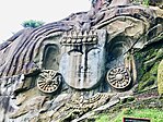
(clockwise from top) Ujjayanta Palace; Tripura Sundari Temple; Neermahal palace; rock-cut sculptures at Unakoti | |
| Etymology: Land near water | |
| Nickname(s): "Hill Tipperah", " Twipra" | |
| Motto(s): Satyameva Jayate (Truth alone triumphs) | |
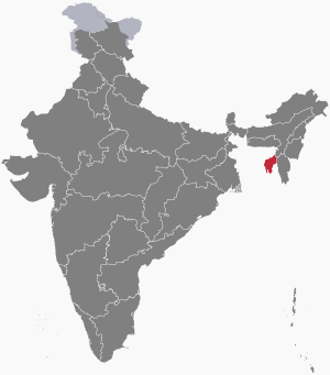
 Location of Tripura in India | |
| Coordinates: 23°50′N 91°17′E / 23.84°N 91.28°E | |
| Country | |
| Region | Northeast India |
| Before was | Princely state of Tripura |
| Admission to union | 15 October 1949[1] |
| As union territory | 1 November 1956 |
| Formation | 21 January 1972 |
| Capital and largest city | Agartala |
| Districts | 8 |
| Government | |
| • Body | Government of Tripura |
| • Governor | Indrasena Reddy[2] |
| • Chief minister | Manik Saha (BJP) |
| • Chief secretary | J.K. Sinha[3] |
| State Legislature | Unicameral |
| • Assembly | Tripura Legislative Assembly (60 seats) |
| National Parliament | Parliament of India |
| • Rajya Sabha | 1 seat |
| • Lok Sabha | 2 seats |
| High Court | Tripura High Court |
| Area | |
• Total | 10,491 km2 (4,051 sq mi) |
| • Rank | 28th |
| Dimensions | |
| • Length | 178 km (111 mi) |
| • Width | 131 km (81 mi) |
| Elevation | 780 m (2,560 ft) |
| Highest elevation | 930 m (3,050 ft) |
| Lowest elevation (Western Part) | 15 m (49 ft) |
| Population (2023)[6] | |
• Total | |
| • Rank | 23rd |
| • Urban | 39.19% |
| • Rural | 60.81% |
| Demonym | Tripuri |
| Language | |
| • Official | [7] |
| • Official script | |
| GDP | |
| • Total (2023–2024) | |
| • Rank | 24th |
| • Per capita | |
| Time zone | UTC+05:30 (IST) |
| ISO 3166 code | IN-TR |
| Vehicle registration | TR |
| HDI (2022) | |
| Literacy (2013) | |
| Sex ratio (2023) | 967♀/1000 ♂ (2nd) |
| Website | tripura |
| Symbols of Tripura | |
 | |
| Foundation day | Tripura Day |
| Bird | Green imperial pigeon |
| Fish | Pabda |
| Flower | Indian rose chestnut |
| Fruit | Queen pineapple |
| Mammal | Phayre's leaf monkey |
| Tree | Agarwood |
| State highway mark | |
 | |
| State highway of Tripura | |
| List of Indian state symbols | |
| †It was elevated from the status of Union territory by the North-Eastern Areas (Reorganisation) Act 1971 | |
Tripura (/ˈtrɪpʊrə, -ərə/)[10] is a state in northeastern India. The third-smallest state in the country, it covers 10,491 km2 (4,051 sq mi); and the seventh-least populous state with a population of 3.67 million.[11] It is bordered by Assam and Mizoram to the east and by Bangladesh to the north, south and west.[12] Tripura is divided into 8 districts and 23 sub-divisions, where Agartala is the capital and the largest city in the state. Tripura has 19 different tribal communities[13] with a majority Bengali population. Bengali, English and Kokborok are the state's official languages.[7]
The area of modern Tripura — ruled for several centuries by the Manikya Dynasty — was part of the Tripuri Kingdom (also known as Hill Tippera). It became a princely state under the British Raj during its tenure, and acceded to independent India in 1947. It merged with India in 1949 and was designated as a 'Part C State' (union territory).[14] It became a full-fledged state of India in 1972.
Tripura lies in a geographically isolated location in India, as only one major highway, National Highway 8, connects it with the rest of the country. Five mountain ranges — Baramura, Atharamura, Longtharai, Shakhan and Jampui Hills — run north to south, with intervening valleys; Agartala, the capital, is located on a plain to the west. The state has a tropical savanna climate, and receives seasonal heavy rains from the south west monsoon.
Forests cover more than half of the area, in which bamboo and cane tracts are common. Tripura has the highest number of primate species found in any Indian state. Due to its geographical isolation, economic progress in the state is hindered. Poverty and unemployment continue to plague Tripura, which has a limited infrastructure. Most residents are involved in agriculture and allied activities, although the service sector is the largest contributor to the state's gross domestic product.
According to the 2011 census, Tripura is one of the most literate states in India, with a literacy rate of 87.75%. Mainstream Indian cultural elements coexist with traditional practices of the ethnic groups, such as various dances to celebrate religious occasions, weddings and festivities; the use of locally crafted musical instruments and clothes; and the worship of regional deities. The sculptures at the archaeological sites Unakoti, Pilak and Devtamura provide historical evidence of artistic fusion between organised and indigenous religions.
- ^ "Historical Background | Tripura State Portal". Archived from the original on 12 February 2015. Retrieved 25 March 2023.
- ^ Reddy, R. Ravikanth (19 October 2023). "Telangana BJP leader Indrasena Reddy appointed as Tripura Governor". The Hindu. Archived from the original on 20 October 2023. Retrieved 20 October 2023.
- ^ "CS Profile | Tripura State Portal". Archived from the original on 25 March 2023. Retrieved 25 March 2023.
- ^ "Know Tripura | Tripura State Portal". tripura.gov.in. Archived from the original on 3 January 2021. Retrieved 23 December 2020.
- ^ "Betalongchhip - Peakbagger.com". www.peakbagger.com. Archived from the original on 24 March 2023. Retrieved 24 March 2023.
- ^ Population Projections for India and States, 2011–2036. July 2020. Archived from the original on 13 March 2023. Retrieved 25 March 2023.
- ^ a b "Report of the Commissioner for linguistic minorities: 52nd report (July 2014 to June 2015)" (PDF). Commissioner for Linguistic Minorities, Ministry of Minority Affairs, Government of India. pp. 79–84. Archived from the original (PDF) on 15 November 2016. Retrieved 16 February 2016.
- ^ "Sub-national HDI – Area Database". Global Data Lab. Institute for Management Research, Radboud University. Archived from the original on 23 September 2018. Retrieved 25 September 2018.
- ^ "Tripura beats Kerala in literacy", The Times of India, timesofindia.indiatimes.com, 8 September 2013, archived from the original on 25 March 2023, retrieved 8 September 2013
- ^ Wells, John C. (2008). Longman Pronunciation Dictionary (3rd ed.). Longman. ISBN 9781405881180.
- ^ Lodrick, Deryck. "Tripura – History, Map, Population, & Facts". Britannica. Archived from the original on 27 January 2022. Retrieved 22 January 2022.
- ^ "Rohingya crisis: Security tightened along India-Myanmar border". Archived from the original on 15 September 2017.
- ^ "people | Tripura Tribal Areas Autonomous District Council". ttaadc.gov.in. Retrieved 23 December 2022.
- ^ Sajal Nag; Tejimal Gurung; Abhijit Choudhury, eds. (2007), Making of the Indian Union: Merger of princely states and excluded areas, Akansha Pub. House, pp. 317, 321, ISBN 978-81-8370-110-5


