Back Río Ucayali Afrikaans نهر أوكايالي Arabic نهر اوكايالى ARZ Ríu Ucayali AST Укаялі Byelorussian Укаялі BE-X-OLD Укаяли (река) Bulgarian উকায়ালি নদী Bengali/Bangla Ucayali (rijeka) BS Riu Ucayali Catalan
This article needs additional citations for verification. (February 2015) |
| Ucayali River | |
|---|---|
 Confluence of the Tambo (from bottom) and Urubamba Rivers (background right) forming the Ucayali River (background left) | |
 Map of the Amazon Basin with the Ucayali River highlighted | |
| Location | |
| Country | Peru |
| Physical characteristics | |
| Source | confluence of the Tambo and Urubamba Rivers |
| • location | Atalaya, Ucayali, Peru |
| Mouth | Amazon River |
• location | confluence with Marañón River, Loreto, Peru |
| Length | 2,238 km (1,391 mi)[1] 1,460 km (910 mi)[2] |
| Basin size | 351,549 km2 (135,734 sq mi)[1] |
| Discharge | |
| • location | Requena, Peru |
| • average | (Period of data: 1990–2006)13,385 m3/s (472,700 cu ft/s)[4]
13,500 m3/s (480,000 cu ft/s) (Confluence of Marañón: ~13,800 m3/s (490,000 cu ft/s)) |
| • minimum | 3,000 m3/s (110,000 cu ft/s)[3] |
| • maximum | 28,000 m3/s (990,000 cu ft/s)[3] |
| Discharge | |
| • location | Pucallpa, Peru (Basin size: 260,733 km2 (100,670 sq mi) |
| • average | (Period of data: 1990–2006)8,931.2 m3/s (315,400 cu ft/s)[4] |
| Basin features | |
| Tributaries | |
| • left | Tambo, Pachitea, Aguaytia, Pacaya, Pisqui, Cushabatay |
| • right | Urubamba, Tamaya, Tapiche |
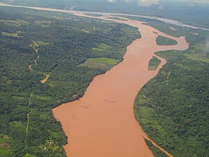
The Ucayali River (Spanish: Río Ucayali, IPA: [ˈri.o wkaˈʝali]) is the main headstream of the Amazon River. It rises about 110 km (68 mi) north of Lake Titicaca, in the Arequipa region of Peru and becomes the Amazon at the confluence of the Marañón close to Nauta city. The city of Pucallpa is located on the banks of the Ucayali.
- ^ a b "Archived copy" (PDF). Archived from the original (PDF) on 2021-11-13. Retrieved 2023-04-06.
{{cite web}}: CS1 maint: archived copy as title (link) - ^ Ziesler, R.; Ardizzone, G.D. (1979). "Amazon River System". The Inland waters of Latin America. Food and Agriculture Organization of the United Nations. ISBN 92-5-000780-9. Archived from the original on 8 November 2014.
- ^ a b "Archived copy" (PDF). Archived from the original (PDF) on 2021-11-13. Retrieved 2023-04-06.
{{cite web}}: CS1 maint: archived copy as title (link) - ^ a b "Nuevo Repositorio Institucional" (PDF). Retrieved 2023-04-06.