Back Umkhanyakude-distriksmunisipaliteit Afrikaans UMkhanyakude District Municipality CEB UMkhanyakude German Distrik uMkhanyakude ID Municipalità distrettuale di Umkhanyakude Italian Umkhanyakude Dutch Umkanyakude NOV Mmasepala Setereke tša Umkhanyakude NSO Umkhanyakude Polish Умкханьякуде Russian
uMkhanyakude
North Uthungulu | |
|---|---|
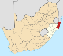
 Location in South Africa | |
| Country | South Africa |
| Province | KwaZulu-Natal |
| Seat | Mkuze[1] |
| Local municipalities | |
| Government | |
| • Type | Municipal council |
| • Mayor | Cllr.Solomon Mkhombo |
| Area | |
• Total | 12,821 km2 (4,950 sq mi) |
| Population (2011)[3] | |
• Total | 625,846 |
| • Density | 49/km2 (130/sq mi) |
| Racial makeup (2011) | |
| • Black African | 98.8% |
| • Coloured | 0.2% |
| • Indian/Asian | 0.2% |
| • White | 0.7% |
| First languages (2011) | |
| • Zulu | 94.6% |
| • English | 1.7% |
| • Southern Ndebele | 1.2% |
| • Other | 2.5% |
| Time zone | UTC+2 (SAST) |
| Municipal code | DC27 |
The uMkhanyakude District Municipality (Zulu: UMasipala wesiFunda sase uMkhanyakude) is the northernmost of the 11 districts of the KwaZulu-Natal province of South Africa. Its seat is Mkuze. It is a very rural district, the largest town being Mtubatuba in the south, with Hluhluwe, Mkuze, Jozini, Kwangwanase and Ingwavuma further to the north. The majority of its 573,353 inhabitants spoke isiZulu as of 2001. The district code is DC27.
The municipality is named after the yellow-barked fever tree, literally meaning "seen from afar" in isiZulu. It contains many areas of outstanding natural beauty such as the St Lucia greater wetland park, Sodwana Bay and Kosi Bay. Game parks include Hluhluwe–iMfolozi, Ndumu and Tembe Elephant Park.
It is one of the two most deprived districts in South Africa according to the District Health Barometer, in terms of unemployment rates, access to piped water and electricity, female-headed households with high numbers of children and low education levels.
- ^ KwaZulu-Natal Top Business | uMkhanyakude District Municipality
- ^ "Contact list: Executive Mayors". Government Communication & Information System. Archived from the original on 14 July 2010. Retrieved 22 February 2012.
- ^ a b c "Statistics by place". Statistics South Africa. Retrieved 27 September 2015.
