Back أم الفحم Arabic ام الفحم ARZ Umm al-Fahm Catalan Umm el Faḥm CEB Umm al-Fahm Czech Umm al-Fahm German Ουμ αλ-Φαχμ Greek Umm al-Fahm Spanish امالفحم Persian Umm al-Fahm Finnish
Umm al-Fahm
| |
|---|---|
City (from 1985) | |
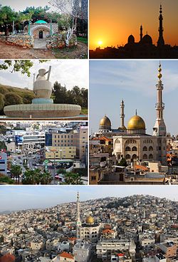
 From the top: Shrine of Sheikh Alexander, Sunset, Nafoura Park, Famous mosques, Main street and Panoramic view | |
| Coordinates: 32°31′10″N 35°09′13″E / 32.51944°N 35.15361°E | |
| Grid position | 164/213 PAL |
| Country | |
| District | |
| Government | |
| • Mayor | Samir Sobhi Mahamed |
| Area | |
• Total | 26,060 dunams (26.06 km2 or 10.06 sq mi) |
| Population (2022)[1] | |
• Total | 58,665 |
| • Density | 2,300/km2 (5,800/sq mi) |
| Name meaning | Mother of Charcoal[2] |
Umm al-Fahm (Arabic: أمّ الفحم ⓘ, Umm al-Faḥm; Hebrew: אוּם אֶל-פַחֶם Um el-Faḥem) is a city located 20 kilometres (12 miles) northwest of Jenin in the Haifa District of Israel. In 2022 its population was 58,665,[1] nearly all of whom are Arab citizens of Israel.[3] The city is situated on the Umm al-Fahm mountain ridge, the highest point of which is Mount Iskander (522 metres (1,713 feet) above sea level), overlooking Wadi Ara. Umm al-Fahm is the social, cultural and economic center for residents of the Wadi Ara and Triangle regions.
- ^ a b "Regional Statistics". Israel Central Bureau of Statistics. Retrieved 21 March 2024.
- ^ Palmer, 1881, p.154
- ^ Zafrir, Rinat (3 December 2007). "Green Cities / Wasting away". Haaretz. Retrieved 25 October 2008.


