Back مقاطعة يونيون (جورجيا) Arabic Union County, Georgia BAR Юниън (окръг, Джорджия) Bulgarian ইউনিয়ন কাউন্টি, জর্জিয়া BPY Union Gông (Georgia) CDO Унион (гуо, Джорджи) CE Union County (kondado sa Tinipong Bansa, Georgia) CEB Union County, Georgia Welsh Union County (Georgia) German Κομητεία Γιούνιον (Τζόρτζια) Greek
Union County | |
|---|---|
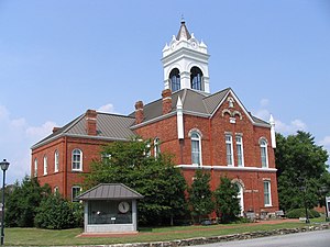
 Old Union County Courthouse in Blairsville | |
 Location within the U.S. state of Georgia | |
 Georgia's location within the U.S. | |
| Coordinates: 34°50′N 83°59′W / 34.83°N 83.99°W | |
| Country | |
| State | |
| Founded | December 3, 1832 |
| Seat | Blairsville |
| Largest city | Blairsville |
| Area | |
• Total | 329 sq mi (850 km2) |
| • Land | 322 sq mi (830 km2) |
| • Water | 7.1 sq mi (18 km2) 2.2% |
| Population (2020) | |
• Total | 24,632 |
| • Density | 76/sq mi (29/km2) |
| Time zone | UTC−5 (Eastern) |
| • Summer (DST) | UTC−4 (EDT) |
| Congressional district | 9th |
| Website | unioncountyga.gov |
Union County is a county in the Northeast region of the U.S. state of Georgia. As of the 2020 census, the population was 24,632.[1] The county seat is Blairsville.[2]
- ^ "Census - Geography Profile: Union County, Georgia". United States Census Bureau. Retrieved December 29, 2022.
- ^ "Find a County". National Association of Counties. Retrieved June 7, 2011.
